Salzgitter Hills

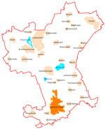
The Salzgitter Hills (German: Salzgitter-Höhenzug, also Salzgitterscher Höhenzug) is an area of upland up to 322.9 metres (1,059 ft) in height, in the Lower Saxon Hills between Salzgitter and Goslar in the districts of Wolfenbüttel and Goslar and in the territory of the independent town of Salzgitter. The hills lie in the German federal state of Lower Saxony. The German name of Salzgitter-Höhenzug is a term used in the northern Harz Foreland, albeit not found on maps, and is used to mean the string of hills north of the Harz Mountains between the towns mentioned above. The state forest of the Salzgitter Hills is managed by several Lower Saxony forestry offices, including the Revierförsterei Salder in Salzgitter-Salder. The Salzgitter Hills can be divided into these four unnamed sections: Northwest section (mainly comprising the Lichtenberge)(up to 254.2 m high; between Holle and Salzgitter-Gebhardshagen) North-central section(up to 275.3 m high; between Salzgitter-Gebhardshagen and Salzgitter-Bad) South-central section(up to 307.0 m high; between Salzgitter-Bad and Liebenburg) Southern section(up to 322.9 m high; between Liebenburg and Goslar-Immenrode and Goslar-Hahndorf)
Excerpt from the Wikipedia article Salzgitter Hills (License: CC BY-SA 3.0, Authors, Images).Salzgitter Hills
Braunschweiger Straße, Salzgitter Salzgitter-Bad (Ortschaft Süd)
Geographical coordinates (GPS) Address Nearby Places Show on map
Geographical coordinates (GPS)
| Latitude | Longitude |
|---|---|
| N 52.05 ° | E 10.366666666667 ° |
Address
Braunschweiger Straße
Braunschweiger Straße
38259 Salzgitter, Salzgitter-Bad (Ortschaft Süd)
Lower Saxony, Germany
Open on Google Maps


