place

The Chessels

Areas of BristolBristol geography stubsEngvarB from June 2017
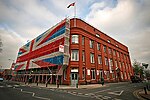
Only Fools and Horses Location The White Horse, 166 West Street, Bedminster, Bristol 1999 (339822278)

The Chessels is an area of Bedminster, Bristol that runs from the midsection of Luckwell Rd to the former White Horse pub on West Street. Chessel Street is the main road. The name Chessel is taken from the name of a field, recorded in 1350. The White Horse was redeveloped into flats by 2013, but was once used as a location for the fictional Nags Head pub in the BBC television series Only Fools and Horses.Chessel Street has a number of streets on either side that are named after gemstones, including Ruby Street, Pearl Street, Beryl Road, Jasper Street and Garnet Street. At the West Street end Chessel Street also turns off into British Road, and at the Luckwell Rd end there is a moderately sized Anglican church, St Aldhelms (built 1906), which is part of the Bedminster Team Ministry. Until as recently as 1980 there was a shop on every corner of the entire street – over 10 shops. These included a bakery, general store, sweet shop and newsagent, a cooker and electrical shop, and a dry cleaner. As of September 2016 there is now just a funeral directors at the West St end and a hair and beauty salon at the Luckwell Rd end, which was the former post office. The post office counter (named The Chessels) was closed as part of Post Office Ltd's post office closure plan. The post office was described in June 2008 by Councillor Mark Wright as "a focal point for the local community in the Chessels since before anyone can remember." In April 2008, (then) MP for Bristol South Dawn Primarolo objected to the proposed closure of both The Chessels and Bedminster Road branches, noting their high importance to the local communities.

Excerpt from the Wikipedia article The Chessels (License: CC BY-SA 3.0, Authors, Images).

The Chessels
Chessel Street, Bristol Bedminster

Geographical coordinates (GPS) Address Nearby Places
placeShow on map

Wikipedia: The ChesselsContinue reading on Wikipedia

Geographical coordinates (GPS)

Latitude Longitude
N 51.43798 ° E -2.60903 °
placeShow on map

Address

Chessel Street 54
BS3 3DN Bristol, Bedminster
England, United Kingdom
mapOpen on Google Maps

Only Fools and Horses Location The White Horse, 166 West Street, Bedminster, Bristol 1999 (339822278)
Share experience

Nearby Places

Spike Island, Bristol

Spike Island is an inner city and harbour area of the English port city of Bristol, adjoining the city centre. It comprises the strip of land between the Floating Harbour to the north and the tidal New Cut of the River Avon to the south, from the dock entrance to the west to Bathurst Basin in the east. The island forms part of Cabot ward. The area between the Docks and New cut to the east of Bathurst Basin is in the neighbourhoods of Redcliffe and St Philip's Marsh.Spike Island was created by William Jessop in the early 19th century, when he constructed the New Cut and converted the former course of the River Avon into the Floating Harbour. Until the Second World War, a lock connected Bathurst Basin with the New Cut, and Spike Island was a genuine island surrounded on all sides by water. However, fears that an aerial attack on this lock at low tide could lead to a disastrous dewatering of the docks led to the lock being filled in. Historically, Spike Island was the site of working quays, shipyards, warehousing and other associated dockside industry. The Bristol Harbour Railway runs the length of the island, and formerly connected these working areas with the railway network. With the redevelopment of the docks, the Island has become an area popular with developers looking to create prime dock side housing such as Baltic Wharf, The Point and Perretts Court. There are also a few restaurants and popular pubs such as The Orchard Inn and The Cottage. Other formerly dock-related buildings have become cultural venues or museums. These include: Spike Island Artspace, a collective of artists' studios located in a former tea-packing factory M Shed, the museum of Bristol, on the site of the former Bristol Industrial Museum, in a former dockside transit shed Bristol Archives in B Bond Warehouse, a former tobacco warehouse Brunel's SS Great Britain, preserved in the dry dock in which she was built CREATE Centre, also in B Bond Warehouse, an ecological art exhibition and Ecohome Underfall Yard, a base for marine-related businesses plus an interactive visitor centre and café.Other historic buildings have been converted into office space, housing small businesses and legal and financial companies such as Creditcall. The path of the harbour railway across Spike Island is proposed for a £38 million rapid transit bus route from Ashton Vale to the city centre. The existing steam railway would be retained, but buses would gain a congestion-free journey into the city. Subject to planning permission and finances, work could start 2012 with services running 2014.