place

Main Building (Torrance High School)

1917 establishments in CaliforniaBuildings and structures on the National Register of Historic Places in Los Angeles County, CaliforniaCommons category link is locally definedHistory of Torrance, CaliforniaMediterranean Revival architecture in California
School buildings completed in 1917School buildings on the National Register of Historic Places in CaliforniaTorrance High School
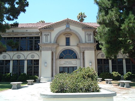
THS facade
THS facade

The Main Building of Torrance High School is located on the campus in Torrance, southwestern Los Angeles County, California. The Main Building was opened to students as Torrance School in 1917.

Excerpt from the Wikipedia article Main Building (Torrance High School) (License: CC BY-SA 3.0, Authors, Images).

Main Building (Torrance High School)
Watson Avenue, Torrance

Geographical coordinates (GPS) Address Nearby Places
placeShow on map

Wikipedia: Main Building (Torrance High School)Continue reading on Wikipedia

Geographical coordinates (GPS)

Latitude Longitude
N 33.830833333333 ° E -118.32027777778 °
placeShow on map

Address

Watson Avenue 1716
90501 Torrance
California, United States
mapOpen on Google Maps

THS facade
THS facade
Share experience

Nearby Places

Pacific Electric Railroad Bridge

The Pacific Electric Railroad Bridge or Southern Pacific Railroad Bridge now officially named the "Pacific Electric Railway- El Prado Bridge" is a historic double-tracked arch bridge located in Torrance, California USA, spanning Torrance Boulevard at Bow Avenue, a short distance west of Western Avenue. It was once part of the north/south San Pedro via Gardena Line of the Pacific Electric Railway, that agency's first interurban line to San Pedro.Torrance, California is a town that was planned on the drawing board. Before 1912 there was no settlement in the area. After splitting off to the east from the Union Tool Company plant which was once a short distance south of the bridge, the line terminated at the new Torrance plant of the Llewellyn Iron Works which was opened in 1916 (and was since 1923 for most of its life a Columbia Steel Company plant). It ran up and over the railroad's east/west Torrance local line in much the same manner as a viaduct and is the only part of the PE which crossed itself in such a manner; indeed, the map on the following reference link refers to the bridge as a viaduct. This was due to the area's geography; simply building a spur off of the main line would have resulted in too steep a climb to the steel mill. The steel mill has since been demolished to make way for the national headquarters of American Honda Motor Company, but the once double-tracked Torrance line was reballasted and rerailed with used welded rail in 2003 and is still in use for local runs by the Union Pacific Railroad. Gone too are the Pacific Electric's Torrance shops at the western branch of the split, now the site of an industrial park still serviced by the aforementioned local line. Designed by Irving Gill and built in 1913 as part of the original layout of the city as determined by Jared Sidney Torrance and Frederick Law Olmsted Jr., the bridge became the city's second entry in the National Register of Historic Places on July 13, 1989 after Torrance High School. It is also listed with the California Office of Historic Preservation.The Pacific Electric Railway- El Prado Bridge, was dedicated as a Local Engineering Landmark by the American Society of Civil Engineers in 2013. Though trackage, turnouts and remnants of a switch remain on the bridge, it is no longer in use nor has it been for quite some time. There is no chance of the bridge returning to service, since the right-of-way at either end has been redeveloped. Nevertheless, the Pacific Electric Railroad Bridge has become a symbol of the city as part of the Torrance Police Department's logo as of January 1, 2000, only the third such change in the department's history.

Madrona Marsh
Madrona Marsh

The Madrona Marsh Preserve, in the city of Torrance in the South Bay region of Southern California, is a seasonal wetland with vernal pools. The 43 acres (17 ha) was a former site of oil wells and is one of the few natural areas remaining within an urban landscape.Formed eons ago when the mountains of the Palos Verdes Peninsula rose to the south, Madrona Marsh is a shallow depression fed by wet season (spring) storms as the name "vernal" indicates. After the rainy season, evaporation, percolation and transpiration reduce the water depth by about one-quarter of an inch (6 mm) per day. By the end of August, the wetland is dry and remains so until the following rainy season. Situated on land that was set aside for oil production in 1924, Madrona Marsh was never developed while the city grew up around the site and remains a valuable natural habitat for birds, reptiles, insects and small mammals.Ongoing efforts are restoring native plants including wildflowers. Plantings may benefit local butterfly species including the Palos Verdes blue. The area has long been popular with bird watchers and The Audubon Society has used Madrona Marsh for their annual bird census since 1967. El Camino College uses it as an outdoor biology and botany lab. The Madrona Marsh Nature Center is operated by the City of Torrance in cooperation with the Friends of the Madrona Marsh. Activities include bird and nature walks, natural history classes and workshops, habitat restoration, science and astronomy programs, art exhibits, and children's nature programs. The center opened in 2001 and features exhibits about the plants, birds and animals of the marsh. The nature center for the Preserve is across the street.