Rancho Corte de Madera
1844 establishments in Alta CaliforniaCalifornia ranchosRanchos of San Mateo County, CaliforniaRanchos of Santa Clara County, CaliforniaWoodside, California

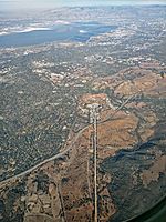
Rancho el Corte de Madera was a 13,316-acre (53.89 km2) Mexican land grant in present day Santa Clara County, California given in 1844 by Governor Manuel Micheltorena to Máximo Martínez. The name translates as "the place where lumber is cut". The roughly triangular shaped grant was west of today's I-280, and bounded on the north by Alambique Creek and San Francisquito Creek, on the south by Los Trancos Creek and Matadero Creek, and on the west by what is now Skyline Boulevard. The grant surrounded Rancho Cañada del Corte de Madera which extended along the Portola Valley. The land grant included parts of present day Woodside, Ladera and Stanford University.
Excerpt from the Wikipedia article Rancho Corte de Madera (License: CC BY-SA 3.0, Authors, Images).Rancho Corte de Madera
Dwight Crowder Path,
Geographical coordinates (GPS) Address Nearby Places Show on map
Geographical coordinates (GPS)
| Latitude | Longitude |
|---|---|
| N 37.39 ° | E -122.19 ° |
Address
Dwight Crowder Path
Dwight Crowder Path
94028
California, United States
Open on Google Maps


