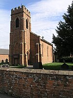
Hungry Bentley
Civil parishes in DerbyshireDerbyshire DalesDeserted medieval villages in Derbyshire

Hungry Bentley is a deserted medieval village and civil parish in the Derbyshire Dales district of Derbyshire, England, between Uttoxeter and Derby. The site is a scheduled monument and has been called the best "depopulated settlement" in Derbyshire. The name Bentley is said to mean a clearing with bent grass. The more unusual appellation of "Hungry" is said to refer to the poor quality of the land and the local inhabitants' poor food.
Excerpt from the Wikipedia article Hungry Bentley (License: CC BY-SA 3.0, Authors, Images).Hungry Bentley
Derby Lane, Derbyshire Dales Hungry Bentley CP
Geographical coordinates (GPS) Address Nearby Places Show on map
Geographical coordinates (GPS)
| Latitude | Longitude |
|---|---|
| N 52.945 ° | E -1.735 ° |
Address
Derby Lane
Derby Lane
DE6 3DJ Derbyshire Dales, Hungry Bentley CP
England, United Kingdom
Open on Google Maps


