place

Cheylesmore

Suburbs of CoventryUse British English from April 2017Wards of Coventry
Quinton pool 5o06
Quinton pool 5o06

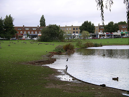
Cheylesmore is a suburb in the southern half of the city of Coventry, West Midlands, England. It is one of Coventry's largest suburbs, sharing borders with Whitley and Stivichall (also spelt Styvechale) in the South, extending into Coventry city centre and bordering with Earlsdon in the North. Locally pronounced as 'Charlesmore' or occasionally 'Chellsmore', Cheylesmore has two shopping parades situated in Daventry Road and Quinton Park. These shops overlook a small park and pool known as Quinton Pool. It takes its name from Cheylesmore Manor. The original name probably derives from 'Chez Les Morts' since a huge plague pit was found during excavations after the Second World War. The city gate leading to the area was labelled as Childsmore Gate on old maps, an alternative etymology of the name.

Excerpt from the Wikipedia article Cheylesmore (License: CC BY-SA 3.0, Authors, Images).

Cheylesmore
Quinton Park, Coventry Cheylesmore

Geographical coordinates (GPS) Address Nearby Places
placeShow on map

Wikipedia: CheylesmoreContinue reading on Wikipedia

Geographical coordinates (GPS)

Latitude Longitude
N 52.393 ° E -1.505 °
placeShow on map

Address

Quinton Lodge Sheltered Housing

Quinton Park
CV3 5QL Coventry, Cheylesmore
England, United Kingdom
mapOpen on Google Maps

Quinton pool 5o06
Quinton pool 5o06
Share experience

Nearby Places

Coventry ring road
Coventry ring road

The A4053 Coventry ring road is a 2.25-mile (3.62 km) ring road in Coventry, England, which forms a complete dual-carriageway loop around the city centre. The road encompasses the old and new Coventry Cathedrals, the city's shopping areas and much of Coventry University. With the exception of one roundabout at junction 1, the ring road's nine junctions are entirely grade separated and closely spaced, with weaving sections between them, some as short as 300 yards (270 m), giving the road a reputation for being difficult to navigate. The junctions include connections with three other A roads: the A4114, A4600 and A429. From the 1930s, Coventry City Council began replacing the city's narrow medieval streets with modern roads, to cope with a rapidly growing population. City architect Donald Gibson began work in 1939 on a city centre redevelopment plan which expanded in scope following World War II, in which large areas of the city were destroyed by German bombs. The shopping area was rebuilt first, followed by the ring road, which was constructed in six stages from 1959. Early stages were built with at-grade junctions, cycle tracks and footpaths, envisaged as a surface-level linear park. Following traffic surveys in the early 1960s, however, the council amended the design to include grade separation and the weaving sections. Research by the city engineer indicated that it was the first urban road in the world to use this configuration at such a small scale. The road was completed in 1974, with an overall cost of £14.5 million (equivalent to £160,800,000 in 2021). As one of the few British cities to see its ring road project pushed to completion, Coventry has received considerable attention as a source of research for post-war architecture. An article by BBC News noted that opinions about the road were varied, concluding that "you either love it or you hate it". The road was the subject of a 2015 series of poetry films and driving on it has been likened to driving a Scalextric car and riding on a roller coaster.