place

Country Heritage Park

Agriculture museums in CanadaFarm museums in CanadaHistory museums in OntarioHistory of agriculture in OntarioMilton, Ontario
Museums in the Regional Municipality of HaltonOpen-air museums in CanadaRural history museums in Canada
CountryHeritagePark
CountryHeritagePark

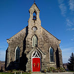
The Country Heritage Park (Formerly the Ontario Agricultural Museum) is located next to Highway 401 and the Niagara Escarpment in Milton, Ontario, Canada, and recreates rural life in the 19th century in Ontario. During the day it also acts as a private school and office, and hosts parties at night. The Museum is affiliated with the Canadian Museums Association, Canadian Heritage Information Network, and the Virtual Museum of Canada.

Excerpt from the Wikipedia article Country Heritage Park (License: CC BY-SA 3.0, Authors, Images).

Country Heritage Park
Highway 401,

Geographical coordinates (GPS) Address Nearby Places
placeShow on map

Wikipedia: Country Heritage ParkContinue reading on Wikipedia

Geographical coordinates (GPS)

Latitude Longitude
N 43.516666666667 ° E -79.9375 °
placeShow on map

Address

Highway 401
L9T 2X7
Ontario, Canada
mapOpen on Google Maps

CountryHeritagePark
CountryHeritagePark
Share experience

Nearby Places

Maplehurst Correctional Complex

Maplehurst Correctional Complex (French: Complexe Correctionnel de Maplehurst) is a correctional facility located in Milton, Ontario for women and men 18 years of age and older. It is a combined maximum security detention centre for remanded prisoners, and medium/maximum correctional centre for offenders sentenced to less than two years. It used to have a separate wing for minors (12 to 17 years of age) but no longer houses them. It is also known colloquially as the "Milton Hilton" or "Muppethurst". In 1972, the government started a $13.5 million construction project for the Maplehurst Correctional Centre. It was completed in 1974 and continues to operate to this day. Sod was turned on the project on February 9, 1973.Maplehurst Correctional Complex was built in the mid-1970s as a replacement for several older facilities including the Milton Jail, Halton County Jail, and the Mimico Correctional Centre, although the latter ultimately remained open. John Main was the facility's first administrator (warden), and came over from Mimico.It was expanded in the late 1980s and again in the early 21st century.At the official opening of the $89 million modernization in 2001, the Ontario government described the complex as the first facility in Ontario's correctional system to feature a new design with pods: self-contained, 192-bed units where inmates spend their day - including program areas and an outdoor space for exercise. The complex is the size of 100 football fields and was the first of so-called "super-jails" in Ontario. General Population, Protective Population and Segregation/Hospital units are all housed within the facility. It shares its location with the adjacent Vanier Centre for Women, a 333-bed medium and maximum security facility for remanded and sentenced female offenders. The prison provides a variety of remedial programs, including life skills, addictions, anger management and Alcoholics Anonymous.

Crawford Lake Conservation Area

Crawford Lake Conservation Area is a conservation area owned and operated by Conservation Halton near the community of Campbellville in Milton, Halton, Ontario, Canada. It is categorized as a regional environmentally sensitive area, an Ontario Area of Natural and Scientific Interest, and part of the Niagara Escarpment world biosphere reserve. The conservation area contains Crawford Lake, a reconstructed Iroquoian village, and several hiking trails. A study conducted in 1971 determined that the lake is meromictic, which makes the lake a prime site for archaeological and geochemical studies. Using pollen analysis, reconstruction of the history of the area over several hundred years was possible. Geochemical analysis of sediment cores has allowed for the reconstruction of the pollution history of the area. This analysis revealed the trends and sources of air pollution over approximately 150 years. The pollen analysis revealed corn pollen, indicating a possible Iroquoian settlement nearby, as corn was a staple of their agriculture. A search of the surrounding area found a grindstone, which would have been used in such a village. Digs of the area just south of the grindstone revealed the foundations of an eleven-longhouse village. The village, thought to be inhabited by either the Wendat (Huron) or Neutral Confederacy peoples, has been reconstructed in the conservation area and is based on many years of research by archaeologists, who continue to study the site. The reconstructed fifteenth century Iroquoian village is open seasonally and for special events. The site offers interpretive programs of Iroquoian life and culture and has three reconstructed longhouses and a palisade, although the original village did not have a palisade. One longhouse is used to display contemporary indigenous art and artifacts recovered from past digs. The longhouses are representative of life in the village at the time, with fireplaces, fur-lined bunk beds, and various items used at the time. The lake is named after the Crawford family, who lived on the site and donated the land to the conservation authority. Their house remained there until it burned down. All that survived was the front porch that was constructed of cement. Photographs of the original house and members of the Crawford family exist. The Crawford family also owned a cedar tree farm on the opposite side of the lake. The conservation area also has 19 kilometres (12 mi) of hiking and cross-country skiing and snowshoeing trails with connections to Bruce Trail. A boardwalk trail circles the lake, protecting the environment while allowing access. The trail is decorated with various sculptures and artistic benches. Another trail leads to the escarpment, and another connects to nearby Rattlesnake Point Conservation Area.