Port Mann
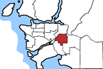
Port Mann townsite was created in 1911 in the municipality of Surrey, British Columbia. The new town was to adjoin the new railway yard and roundhouse forming the terminus of the new trans-national rail-line operated by Canadian Northern Railway. It was named for Donald Mann, a partner in the building of the Canadian Northern Railway.: 211 Newspaper quoted that the town was intended to be a model town. Purchase of sections had been completed by 1911 and clearing of the forest had begun. The sale of lots began in March 1912 and by June 1912 all land in the townsite had been sold. Four million dollars worth of land was sold in Port Mann. Borrowing from mid-nineteenth century notions of Baron Haussmann’s Paris, Port Mann was laid out by landscape architect Frederick S. Todd with streets radiating from a central circus in the residential section. The business sector was to cluster around a large open square. In June 1912 the Toronto World also published that Port Mann would be the site of a large scale steel mill by Carnegie Steel Company of Pittsburgh as well as the site of flour mill, and grain elevators by International Milling, and the site of a large dry dock and shipbuilding yards.
Excerpt from the Wikipedia article Port Mann (License: CC BY-SA 3.0, Authors).Port Mann
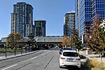
Grosvenor Road, Surrey Port Mann
Geographical coordinates (GPS) Address Nearby Places Show on map
Geographical coordinates (GPS)
| Latitude | Longitude |
|---|---|
| N 49.21 ° | E -122.825 ° |
Address
Grosvenor Rd (SB) at 114 Ave
Grosvenor Road
V3T 5A1 Surrey, Port Mann
British Columbia, Canada
Open on Google Maps


