Arabellapark
Bavaria building and structure stubsBuildings and structures in MunichUpper Bavaria geography stubs
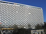
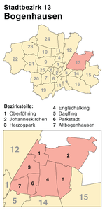
Arabellapark is a residential and commercial area in the Bogenhausen district of Munich, Germany, which was developed with the construction of multiple buildings from 1965 to 1998. It is one of the largest urban expansion projects of the period after World War II in Munich. It takes its name from the Arabellastrasse, which runs through the project site.
Excerpt from the Wikipedia article Arabellapark (License: CC BY-SA 3.0, Authors).Arabellapark
Rosenkavalierplatz, Munich Parkstadt (Bogenhausen)
Geographical coordinates (GPS) Address Nearby Places Show on map
Geographical coordinates (GPS)
| Latitude | Longitude |
|---|---|
| N 48.1519 ° | E 11.6203 ° |
Address
Rosenkavalierplatz 10
81925 Munich, Parkstadt (Bogenhausen)
Bavaria, Germany
Open on Google Maps


