Geography of Réunion
Geography of RéunionRéunion geography stubs

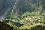
Réunion is an island in Southern Africa, in the Indian Ocean, east of Madagascar. It is an overseas region of France. The total area of the island is 2,512 km², of which 10 km² is water. The island has a coastline of 207 km. The maritime claims of Réunion include an exclusive economic zone of 200 nautical miles, and a territorial sea of 12 nautical miles (22 km). Reunion is geologically situated in the Somali plate.
Excerpt from the Wikipedia article Geography of Réunion (License: CC BY-SA 3.0, Authors, Images).Geography of Réunion
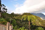
Sentier de Takamaka, Saint-Benoît
Geographical coordinates (GPS) Address Nearby Places Show on map
 Continue reading on Wikipedia
 Geographical coordinates (GPS)
| Latitude | Longitude |
|---|---|
| N -21.1 ° | E 55.6 ° |
Address
Sentier de Takamaka
Sentier de Takamaka
97431 Saint-Benoît
Réunion, France
Open on Google Maps