place

Tibberton, Shropshire

Former civil parishes in ShropshireShropshire geography stubsTelford and WrekinVillages in Shropshire
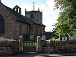
Tibberton Church geograph.org.uk 227773

Tibberton is a village and former civil parish, now in the parish of Tibberton and Cherrington, in the borough of Telford and Wrekin and ceremonial county of Shropshire, England. In 1961 the parish had a population of 319. On 1 April 1988 the parish was abolished to form "Tibberton & Cherrington".It is a fairly small village with some new barn conversions contrasting with the older houses. Much new housing has been planned by the borough council for the village however. The River Meese flows just to the north of the village. The B5062 road runs less than a mile away, to the south. In the way of amenities, Tibberton has a pub, The Sutherland Arms, and a small primary school. Following two years without a shop, a community shop opened in the village in December 2011. Newport, the nearest town, is only 4 miles (6.4 km) away, to the east. There is a holy well within the parish of Tibberton, marked on the 1:50 000 map and signposted on the roads. The well has given its name to the district round about, but is not easy to locate on the ground. A gully takes one from the road, turns to a path, and the well is in a little wood. Water from the spring has carved out a little stream running down the short distance to the River Meese.Nearby is the small village of Cherrington.

Excerpt from the Wikipedia article Tibberton, Shropshire (License: CC BY-SA 3.0, Authors, Images).

Tibberton, Shropshire
Church View,

Geographical coordinates (GPS) Address Nearby Places
placeShow on map

Wikipedia: Tibberton, ShropshireContinue reading on Wikipedia

Geographical coordinates (GPS)

Latitude Longitude
N 52.779 ° E -2.474 °
placeShow on map

Address

Church View

Church View
TF10 8LJ , Tibberton and Cherrington
England, United Kingdom
mapOpen on Google Maps

Tibberton Church geograph.org.uk 227773
Share experience

Nearby Places

Kynnersley
Kynnersley

Kynnersley is a village in Shropshire, England. Kynnersley lies in the borough of Telford and Wrekin, in a remote, rural location north of Telford. The village has a population of approximately 180 based on the 2001 census and taking into account new housing, increasing to 284 at the 2011 census. The population is expected to grow slightly as further new developments take place especially as former farm buildings are converted to residential use. Kynnersley has a small Church of England church, parts of which date from the 13th Century, surmounted by an unusual central bell tower. There is a small village hall of wooden construction which was probably once part of a military barracks (on another site). The village also contains a set of water pumps, still in situ but now out of service, that provided water from an underground pipe system fed from a wind pump. The oldest house in the village is the (grade 2 listed) Whym Cottage, a beamed house with walls of wattle and daub, part of which dates from the 16th century. Kynnersley is situated on the North Shropshire Weald Moors, an area of wetlands which have been drained for agricultural use using a series of drains or "strines". Most of the farming land was originally part of the estate of the Duke of Sutherland and several houses in the village are 'Duke of Sutherland Cottages' which have a distinctive architectural style. The "Dukes Drive" is a lane that leads directly from Kynnersley to the Duke of Sutherland memorial at Lilleshall In the centre of the village is a small triangle of raised land known as the Whim. The oak tree in the middle of the Whim is said to have been the hanging tree for the local court house. The old court house itself is now part of the farm buildings of Manor Farm and is in a poor state of repair. Robert Burn (1829-1904), classical scholar and archaeologist, was born at Kynnersley when his father was rector of the parish.