Barnbruch
Forests and woodlands of Lower SaxonyGifhorn (district)Nature reserves in Lower SaxonyWetlands of GermanyWolfsburg

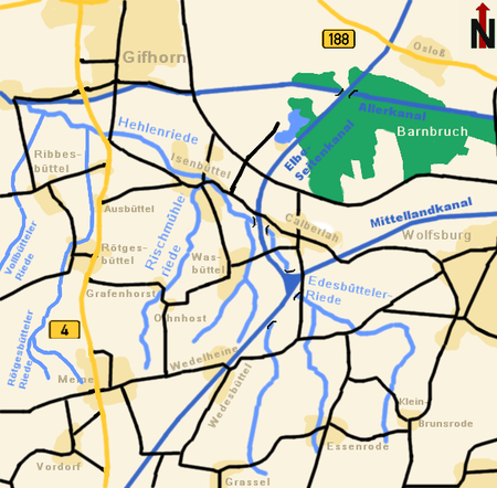
The Barnbruch is a wetland of international importance in the old glacial valley of the river Aller that provides a habitat for endangered species of birds, amphibians and insects. It lies between the city of Wolfsburg and town of Gifhorn and consists of an enclosed woodland area of around 1,500 hectares (3,700 acres) with surrounding meadows and pastures. This low-lying depression lies partly within the territory of the city of Wolfsburg and partly within Gifhorn district. Together with the Drömling around 15 km to the east, the Barnbruch is the most valuable ecological lowland region along the upper course of the Aller.
Excerpt from the Wikipedia article Barnbruch (License: CC BY-SA 3.0, Authors, Images).Barnbruch
Serviceweg am Elbe-Seitenkanal Ost, Samtgemeinde Isenbüttel
Geographical coordinates (GPS) Address Nearby Places Show on map
Geographical coordinates (GPS)
| Latitude | Longitude |
|---|---|
| N 52.45643 ° | E 10.65262 ° |
Address
Naturschutzgebiet Barnbruch
Serviceweg am Elbe-Seitenkanal Ost
38547 Samtgemeinde Isenbüttel
Lower Saxony, Germany
Open on Google Maps


