place

Bat Chum

10th-century Buddhist templesAngkorian sites in Siem Reap ProvinceBuddhist temples in Siem Reap ProvinceCambodian building and structure stubs
Bat Chum 2020 13
Bat Chum 2020 13

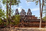
Bat Chum (Khmer: ប្រាសាទបាទជុំ) is a small temple built by Kavindrarimathana, a learned Buddhist minister of Khmer king Rajendravarman, at the middle of the 10th century. It is about 400 meters (1,300 ft) south of Srah Srang, at Angkor, Cambodia. It consists of three inline brick towers (in poor conditions at present), standing on the same platform, surrounded by an enclosure and a moat, with a single gopura to the east. On the doorjambs there are Buddhist inscriptions that mention Kavindrarimathana, the "architect" (or official in charge for construction) who built Srah Srang, East Mebon, and maybe planned the temple-mountain of Pre Rup. The latter was dedicated in 960 AD, shortly before death of the architect. There were houses and a Buddhist monastery near the temple, but these wooden structures have been gone for a long time.During the excavations in 1952, in the northern and central towers, flagstones showing a yantra were found, which George Coedès was able to reconstitute and with extreme difficulty link to the Buddhist divinities mentioned on doorjambs.In every tower there is a different inscription signed by three different persons. The last verse of each of the three refers to the elephants as "dyke breakers".

Excerpt from the Wikipedia article Bat Chum (License: CC BY-SA 3.0, Authors, Images).

Bat Chum
Grand Circuit / Petit Circuit, Siem Reap

Geographical coordinates (GPS) Address External links Nearby Places
placeShow on map

Wikipedia: Bat ChumContinue reading on Wikipedia

Geographical coordinates (GPS)

Latitude Longitude
N 13.424827777778 ° E 103.90758611111 °
placeShow on map

Address

ប្រាសាទបាទជុំ

Grand Circuit / Petit Circuit
Siem Reap
Siem Reap, Cambodia
mapOpen on Google Maps

linkWikiData (Q2887754)
linkOpenStreetMap (227985269)

Bat Chum 2020 13
Bat Chum 2020 13
Share experience

Nearby Places

East Mebon
East Mebon

The East Mebon (Khmer: ប្រាសាទមេបុណ្យខាងកើត) is a 10th Century temple at Angkor, Cambodia. Built during the reign of King Rajendravarman, it stands on what was an artificial island at the center of the now dry East Baray reservoir.: 73–75 : 116  The East Mebon was dedicated to the Hindu god Shiva and honors the parents of the king. Its location reflects Khmer architects’ concern with orientation and cardinal directions. The temple was built on a north–south axis with Rajendravarman's state temple, Pre Rup, located about 1,200 meters to the south just outside the baray. The East Mebon also lies on an east–west axis with the palace temple Phimeanakas, another creation of Rajendravarman's reign, located about 6,800 meters due west. Built in the general style of Pre Rup, the East Mebon was dedicated in 953 AD. It has two enclosing walls and three tiers. It includes the full array of durable Khmer construction materials: sandstone, brick, laterite and stucco. At the top is a central tower on a square platform, surrounded by four smaller towers at the platform's corners. The towers are of brick; holes that formerly anchored stucco are visible. The sculpture at the East Mebon is varied and exceptional, including two-meter-high free-standing stone elephants at corners of the first and second tiers. Religious scenes include the god Indra atop his three-headed elephant Airavata, and Shiva on his mount, the sacred bull Nandi. Carving on lintels is particularly elegant. Visitors looking out from the upper level today are left to imagine the vast expanses of water that formerly surrounded the temple. Four landing stages at the base give reminder that the temple was once reached by boat.

East Baray

The East Baray (Khmer: បារាយណ៍ខាងកើត), or Yashodharatataka, is a now-dry baray, or artificial body of water, at Angkor, Cambodia, oriented east–west and located just east of the walled city Angkor Thom. It was built around the year 900 AD during the reign of King Yasovarman.: 113, 116  Fed by the Siem Reap River flowing down from the Kulen Hills, it is the second-largest baray in the Angkor region (after the West Baray) and one of the largest handcut water reservoirs on Earth, measuring roughly 7.5 kilometers by 1830 m and holding over 55 million cubic meters of water. Stones bearing inscriptions that mark the construction of the baray have been found at all four of its corners.: 65  The labour and organization necessary for its construction were staggering: Its dikes contain roughly 8 million cubic meters of fill.: 68  Scholars are divided on the purpose of this and other barays. By some theories, they held water for irrigation, but no inscription has been found mentioning such a function. Other theories say that barays served primarily a symbolic purpose in Khmer religious life, representing the seas of creation that surround Mount Meru, home of the Hindu gods.: 60  The East Baray today contains no water; farmers till crops on its bed. But its outlines remain clearly visible in satellite photographs. In the middle of the baray is the East Mebon temple, located on elevated ground that was an island in the days when the baray contained water.