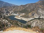
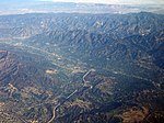
Station Fire (2009)

The Station Fire was the largest wildfire of the 2009 California wildfire season, as well as the largest wildfire in the history of Los Angeles County, that burned in the Angeles National Forest, igniting on August 26, 2009 near the U.S. Forest Service ranger station on the Angeles Crest Highway. Two firefighters, Captain Tedmund Hall and Firefighter Specialist Arnie Quinones, died on August 30, when their fire truck plunged off a cliff during an attempt to set backfires to slow the blaze. The blaze threatened 12,000 structures in the National Forest and the nearby communities of La Cañada Flintridge, Pasadena, Glendale, Acton, La Crescenta, Juniper Hills, Littlerock and Altadena, as well as the Sunland and Tujunga neighborhoods of the City of Los Angeles. Many of these areas faced mandatory evacuations as the flames drew near, but as of September 6, all evacuation orders were lifted. The Station Fire burned on the slopes of Mount Wilson, threatening numerous television, radio and cellular telephone antennas on the summit, as well as the Mount Wilson Observatory, which includes several historically significant telescopes and multimillion-dollar astronomical facilities operated by UCLA, USC, UC Berkeley and Georgia State University. A 40-mile (64-kilometer) stretch of the Angeles Crest Highway was closed until 2010, due to guardrail and sign damage, although the pavement remained largely intact.
Excerpt from the Wikipedia article Station Fire (2009) (License: CC BY-SA 3.0, Authors, Images).Station Fire (2009)
Angeles Crest Highway, Pasadena
Geographical coordinates (GPS) Address Nearby Places Show on map
Geographical coordinates (GPS)
| Latitude | Longitude |
|---|---|
| N 34.251 ° | E -118.195 ° |
Address
Angeles Crest Highway
Angeles Crest Highway
91011 Pasadena
California, United States
Open on Google Maps


