place

Jacob's Pillow

Contemporary danceDance festivals in the United StatesDance in MassachusettsDance schools in the United StatesDance venues
Event venues on the National Register of Historic Places in MassachusettsHistoric districts on the National Register of Historic Places in MassachusettsNRHP infobox with nocatNational Historic Landmarks in MassachusettsNational Register of Historic Places in Berkshire County, MassachusettsTourist attractions in Berkshire County, MassachusettsUnited States National Medal of Arts recipientsUse American English from August 2023Use mdy dates from August 2023
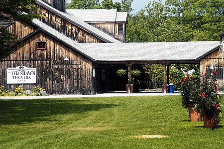
Ted Shawn Theatre
Ted Shawn Theatre

Jacob's Pillow is a dance center, school and performance space located in Becket, Massachusetts, in the Berkshires. The organization is known for a Summer dance festival. The facility also includes a professional school and extensive archives as well as year-round community programs. The facility itself was listed as a National Historic Landmark District in 2003.

Excerpt from the Wikipedia article Jacob's Pillow (License: CC BY-SA 3.0, Authors, Images).

Jacob's Pillow
George Carter Road,

Geographical coordinates (GPS) Address Nearby Places
placeShow on map

Wikipedia: Jacob's PillowContinue reading on Wikipedia

Geographical coordinates (GPS)

Latitude Longitude
N 42.264444444444 ° E -73.118055555556 °
placeShow on map

Address

George Carter Road 698
01223
Massachusetts, United States
mapOpen on Google Maps

Ted Shawn Theatre
Ted Shawn Theatre
Share experience

Nearby Places

Sherwood Forest, Massachusetts

Sherwood Forest is an area within the town of Becket, Massachusetts. Originally established as a vacation community in the 1960s, the Sherwood Forest Road Maintenance District was established in 1982 with the approval of the Massachusetts State Senate and signed into existence by Governor of Massachusetts Edward J. King. The Sherwood Forest Lake District was established in 2010 to take over maintenance of the community's three lakes and their associated dams. Through agreement between the town and Sherwood Forest Enterprises, the real estate development company that created the area, the town of Becket is not responsible for things such as asphalt road maintenance and snow removal. Named after Sherwood Forest in Nottinghamshire, England, with its association with the legend of Robin Hood, this area has street names that include the following: Maid Marion Lane, Little John Drive, Prince John Drive, King Arthur Drive, Knight Drive, Sir Galahad Drive, Whistling Arrow, Nottingham Courts, Nottingham Circle, Alan A Dale Drive, King Richard Drive, King Richard Lane, Sir George Drive, Black Arrow Way, Golden Knight Lane, Jester's Lane, Jester's Court, Golden Knight Court, Bowman's Lane, Minstrel's Way, Flaming Arrow Lane, Prince Paul Path, Prince Paul Lane, Castle Lane, Olde Carriage Road, Robin Hood Lane, Woodmen's Lane, Forest Lane, Blue-Bowar Lane, Arrowhead Lane, Woodmen's Path, Sir Edward's Way, King Richards Court, Singing Sword Lane, Excalibur Drive, Green Wood Court, Hill-top Court, Mountain Dale Court, Pine Dale Court, Pine Dale Circle, Sir Walter Road, Sir Walter Lane, Count Edward's Way, Excalibur Court, Excalibur Lake Drive, Lady of the Lake Courts

Tyringham Cemetery
Tyringham Cemetery

Tyringham Cemetery is a historic cemetery section just outside the historic center of Tyringham, Massachusetts. The 3.67 acres (1.49 ha) property lies on the west side of Church Street, opposite the Union Church. The historically designated portion of the cemetery excludes a 4 acres (1.6 ha) parcel that was purchased in the 2000s.Housatonic Township #1, of which Tyringham was a part, was settled in 1739, and was incorporated as Tyringham in 1767. Its original town center is located in Monterey, which separated in 1847. The current town center developed around the first meeting house to be built in the northern section of the township, around 1779. Its precise location is not known, but is believed to be within the bounds of the cemetery; one potential location is indicated by a stone marker.The cemetery is ringed by an iron picket fence donated in 1892 by the Hale family. It contains more than 800 gravestones, dating from 1797 to the present. The earliest stones were generally made for marble, which was quarried from nearby Berkshire County towns, while later monuments were made of granite. An unusually large number of markers (fourteen) are made of "white bronze", marketed by the Monumental Bronze Company of Bridgeport, Connecticut between 1874 and 1914. Two unusual markers are in the shape of truncated tree trunks, their inscriptions incised on scrolls that appear to be suspended from the top of the marker; perhaps in a contrast to their elaborate nature, they commemorate working-class individuals. Prominent burials in the cemetery include members of the Garland and Hale families, both of which have lineage to the town's early settlers.