Gladenbach Uplands

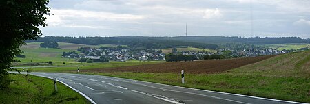
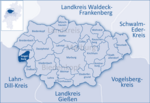
The Gladenbach Uplands (German: Gladenbacher Bergland), named after their central town of Gladenbach, is a range of hills up to 609 m high in the Rhine Massif in Germany, on the junction of the Rothaar Mountains (north and northwest), Westerwald (southwest), (Eastern) Hintertaunus (in the south) and West Hesse Highlands in the east. It lies in Central Hesse within the districts of Marburg-Biedenkopf, Lahn-Dill and Gießen within the so-called Lahn-Dill-(Dietzhölze-) loop. Small parts of the Upper Lahn Valley in the northwest belong, together with the town of Bad Laasphe, also to the district of Siegen-Wittgenstein, North Rhine-Westphalia. The Gladenbach Uplands are geographical unit 320 which is part of the natural region 32, the Westerwald, in Germany's system of natural regions. The Gladenbach Highlands is largely coextensive with the Lahn-Dill Uplands Nature Park which extends further west, however, but is somewhat less extensive in the southeast and whose boundaries tend to line up with those of the sponsoring municipalities. In addition, not insignificant areas belong to the historical Hessian Hinterland, which is why the two named articles refer to one another, as far as regional associations, culture and history are concerned. Geology and mining will be largely covered in the article on the Lahn-Dill Region
Excerpt from the Wikipedia article Gladenbach Uplands (License: CC BY-SA 3.0, Authors, Images).Gladenbach Uplands
K 53, Siegbach
Geographical coordinates (GPS) Address Nearby Places Show on map
Geographical coordinates (GPS)
| Latitude | Longitude |
|---|---|
| N 50.7882 ° | E 8.42869 ° |
Address
Fernsehturm Angelburg
K 53
35713 Siegbach (Hirzenhain)
Hesse, Germany
Open on Google Maps


