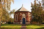
Weston Hills, Lincolnshire
Hamlets in LincolnshireLincolnshire geography stubsSouth Holland, LincolnshireUse British English from October 2014

Weston Hills is a hamlet in the civil parish of Weston in the South Holland district of Lincolnshire, England. Weston Hills, a linear village on a north–south axis, is situated approximately 2 miles (3 km) east from the town of Spalding. Its highest point is 10 feet (3.0 m) above sea level. On 2 October 1942, an American Boeing B-17F bomber crashed at Weston Hills.A McDonnell Douglas F-15 Eagle fighter jet crashed in a field next to Weston Hills on 8 October 2014. The pilot ejected and survived the crash; no injuries were reported.The local school is Weston Hills C of E Primary School.
Excerpt from the Wikipedia article Weston Hills, Lincolnshire (License: CC BY-SA 3.0, Authors, Images).Weston Hills, Lincolnshire
Broad Gate, South Holland
Geographical coordinates (GPS) Address Nearby Places Show on map
Geographical coordinates (GPS)
| Latitude | Longitude |
|---|---|
| N 52.77436 ° | E -0.09922 ° |
Address
Broad Gate
Broad Gate
PE12 6DX South Holland
England, United Kingdom
Open on Google Maps


