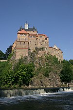
Saxon Loess Fields
The Saxon Loess Fields (German: Sächsisches Lössgefilde) refer to a natural region that lies mainly within the state of Saxony in central Germany. In addition, small areas of this region extend to the northwest and west into Saxony-Anhalt (the land around Weißenfels), to the southeast into Thuringia (the region around Altenburg) and to the northeast into Brandenburg. It more-or-less combines the BfN's major regions listed as D19 Saxon Upland and Ore Mountain Foreland, (Sächsisches Hügelland und Erzgebirgsvorland) and D14, Upper Lusatia (Oberlausitz); only the range of Central Uplands hills, the Lusatian Mountains, has been excluded and instead forms part of the Saxon Highlands and Uplands (Sächsisches Bergland und Mittelgebirge).
Excerpt from the Wikipedia article Saxon Loess Fields (License: CC BY-SA 3.0, Authors).Saxon Loess Fields
Weißthal, Mittweida
Geographical coordinates (GPS) Address Nearby Places Show on map
Geographical coordinates (GPS)
| Latitude | Longitude |
|---|---|
| N 51 ° | E 13 ° |
Address
Weißthal
Weißthal
09648 Mittweida
Saxony, Germany
Open on Google Maps


