place

Lübbenau

Populated places in Oberspreewald-LausitzTowns in Brandenburg
Spreewald 04 2016 img03 canal near Luebbenau

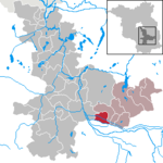
Lübbenau (German pronunciation: [lʏbəˈnaʊ], Lower Sorbian: Lubnjow [ˈlubnʲow]; officially Lübbenau/Spreewald, L.S. Lubnjow/Błota [ˈbwɔta] (meaning Lübbenau/Spree Forest)) is a town in the Upper Spree Forest-Lusatia District of Brandenburg, Germany. It is located in the bilingual German/Sorbian region of (Lower) Lusatia, on the river Spree, where this forms a large inland delta surrounded by woodland, called "Spree Forest", about 82 km (51 mi) southeast of Berlin. The town is best known through the incorporated villages of Lehde/Lědy and Leipe/Lipje, villages where there just exist anabranches of the Spree River instead of streets.

Excerpt from the Wikipedia article Lübbenau (License: CC BY-SA 3.0, Authors, Images).

Lübbenau
Poststraße,

Geographical coordinates (GPS) Address Nearby Places
placeShow on map

Wikipedia: LübbenauContinue reading on Wikipedia

Geographical coordinates (GPS)

Latitude Longitude
N 51.866666666667 ° E 13.966666666667 °
placeShow on map

Address

An der Poststraße II

Poststraße
03222
Brandenburg, Germany
mapOpen on Google Maps

Spreewald 04 2016 img03 canal near Luebbenau
Share experience

Nearby Places

Spree Forest
Spree Forest

The Spree Forest (German: Spreewald, pronounced [ˈʃpʁeːˌvalt] (listen); Lower Sorbian: Błota, i.e. 'the Swamps') is a large inland delta of the river Spree, and a historical cultural landscape located in the region of (Lower) Lusatia, in the state of Brandenburg, Germany, about 100 km southeast of Berlin and close to the city of Cottbus (L.S. Chóśebuz). The Spree Forest is located within the settlement area of the (Lower) Sorbs, and the region is officially bilingual, German and Lower Sorbian. As extensive floodplain and bog landscape, the Spree Forest was designated a biosphere reserve by UNESCO in 1991, called Biosphärenreservat Spreewald (biosferowy rezerwat Błota). It is known for its traditional irrigation system, consisting of more than 200 small canals (called Fließe; total length: 1,300 kilometres or 810 miles) within the 484-square-kilometre (187 sq mi) area, for its unique flora and fauna, and for its traditional flat-bottomed boats, the Spreewaldkähne. The landscape was shaped during the last Ice Age. The region's most populous towns are Lübbenau/Spreewald (L.S. Lubnjow/Błota), which is known for the incorporated villages of Lehde (Lědy) and Leipe (Lipje), the villages with canals instead of streets, and Lübben (Spreewald) (Lubin (Błota)). Other notable towns are Vetschau/Spreewald (Wětošow/Błota) with its reconstructed Old Slavic fortified wooden settlement (gord) Slawenburg Raddusch (Radušańske słowjańske groźišćo), and Burg (Spreewald) (Bórkowy (Błota)).