place

Nick's Cove, California

Resorts in CaliforniaRestaurants in California
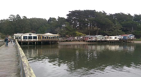
Nick's Cove 2016
Nick's Cove 2016

Nick's Cove is the site of a long-standing restaurant and vacation camp in Marin County, California. It is on the northeast shore of Tomales Bay 3.25 miles (5.2 km) south-southwest of Tomales, at an elevation of 7 feet (2 m). Hog Island is in the middle of Tomales Bay, to the west of Nick's Cove, and Point Reyes National Seashore constitutes the western landmass on the opposite side of the bay. The name honors Nick Kojich, who in 1931 opened a seafood restaurant at this location, which is still in operation.

Excerpt from the Wikipedia article Nick's Cove, California (License: CC BY-SA 3.0, Authors, Images).

Nick's Cove, California
Shoreline Highway,

Geographical coordinates (GPS) Address Nearby Places
placeShow on map

Wikipedia: Nick's Cove, CaliforniaContinue reading on Wikipedia

Geographical coordinates (GPS)

Latitude Longitude
N 38.199722222222 ° E -122.92111111111 °
placeShow on map

Address

Miller Boat Launch Public Parking

Shoreline Highway
94940
California, United States
mapOpen on Google Maps

Nick's Cove 2016
Nick's Cove 2016
Share experience

Nearby Places

Hog Island (Tomales Bay)

Hog Island is an island roughly 2 acres (0.8 ha) in size located approximately 5 mi (8 km) south of the entrance to Tomales Bay in the West Marin area of Marin County, California. While waters to its west are deep enough for small ships to enter Tomales Bay, at low tide the shallows to the east may be wadeable to the eastern shore of the bay. Unsuspecting vessels have run aground in that region a number of times. However, as it is some distance from the mouth of Tomales Bay, Hog Island does not experience the large sudden waves that characterize the Tomales Bay Bar entrance region.The name Hog Island reportedly came from a wild 1870s incident, in which a barge carrying a load of pigs caught fire and was grounded on the island to avoid sinking—at which point the pigs escaped onto the island until they were rounded up again. The island lends its name to the Hog Island Oyster Company, which produces shellfish on Tomales Bay, several miles south of Hog Island. The San Andreas fault runs through the center of Tomales Bay, past Hog Island. Local legend claims that Hog Island and nearby Duck Island (also known as "Piglet") were once connected, but separated as a result of the 1906 San Francisco earthquake. While land deeds from the 1880s indicate that the two islands were separate before the earthquake, the two islands are (and have been) intermittently linked by a sand spit exposed at low tide. The Inverness Yacht Club hosts an annual sailboat race around the island. Competing boats sail from the club, around the island, and back to the club again.

Tomales Bay
Tomales Bay

Tomales Bay is a long, narrow inlet of the Pacific Ocean in Marin County in northern California in the United States. It is approximately 15 mi (24 km) long and averages nearly 1.0 mi (1.6 km) wide, effectively separating the Point Reyes Peninsula from the mainland of Marin County. It is located approximately 30 mi (48 km) northwest of San Francisco. The bay forms the eastern boundary of Point Reyes National Seashore. Tomales Bay is recognized for protection by the California Bays and Estuaries Policy. On its northern end, it opens out onto Bodega Bay, which shelters it from the direct current of the Pacific (especially the California Current). The bay is formed along a submerged portion of the San Andreas Fault. Oyster farming is a major industry on the bay. The two largest producers are Hog Island Oyster Company and Tomales Bay Oyster Company, both of which retail oysters to the public and have picnic grounds on the east shore. Hillsides east of Tomales Bay are grazed by cows belonging to local dairies. There is also grazing land west of the bay, on farms and ranches leased from Point Reyes National Seashore. The bay sees significant amounts of water sports including sailing, kayaking, fishing and motor boating. Watercraft may be launched on Tomales Bay from the public boat ramp at Nick's Cove, north of Marshall. The sand bar at the mouth of Tomales Bay is notoriously dangerous, with a long history of small-boat accidents. The California Office of Environmental Health Hazard Assessment (OEHHA) has developed a safe eating advisory for fish caught here, based on levels of mercury or PCBs found in local species.Towns bordering Tomales Bay include Inverness, Inverness Park, Point Reyes Station, and Marshall. Additional hamlets include Nick's Cove, Spengers, Duck Cove, Shallow Beach, and Vilicichs. Dillon Beach lies just to the north of the mouth of the bay, and Tomales just to the east.