place

Fort Miller, California

1852 establishments in CaliforniaAmerican Civil War army postsAmerican Civil War fortsCalifornia Historical LandmarksCalifornia in the American Civil War
Demolished buildings and structures in CaliforniaFormer buildings and structures in CaliforniaFormer settlements in Madera County, CaliforniaForts in CaliforniaHistory of Madera County, California
Historic American Buildings Survey Robert W. Kerrigan, Photographer 1935 1936 VIEW FROM EAST Fort Miller Hospital, Lake Millerton, Millerton, Madera County, CA HABS CAL,10 MILL,1C 1

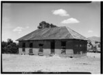
Fort Miller (originally, Camp Barbour) is a former fort on the south bank of the San Joaquin River in what is now Fresno County, California, United States. It lay at an elevation of 561 feet (171 m). The site is now under Millerton Lake, formed by the Friant Dam in 1944. It is registered as California Historical Landmark #584.

Excerpt from the Wikipedia article Fort Miller, California (License: CC BY-SA 3.0, Authors, Images).

Fort Miller, California

Geographical coordinates (GPS) Address Nearby Places
placeShow on map

Wikipedia: Fort Miller, CaliforniaContinue reading on Wikipedia

Geographical coordinates (GPS)

Latitude Longitude
N 37.015277777778 ° E -119.65944444444 °
placeShow on map

Address

Madera County


California, United States
mapOpen on Google Maps

Historic American Buildings Survey Robert W. Kerrigan, Photographer 1935 1936 VIEW FROM EAST Fort Miller Hospital, Lake Millerton, Millerton, Madera County, CA HABS CAL,10 MILL,1C 1
Share experience

Nearby Places

Temperance Flat Dam
Temperance Flat Dam

Temperance Flat Dam is a proposed dam project on the San Joaquin River west of Auberry, California. Construction of the dam is on hold. The dam's main purpose would be to supplement storage capacity in the upper San Joaquin River basin. Under the current proposal, Temperance Flat would slightly more than double water storage on the San Joaquin River from below Friant Dam. The project is highly controversial because it would flood scenic canyons and historic sites along the San Joaquin River, and impact upstream hydroelectricity generation. The Bureau of Reclamation estimates the construction costs will be between US$2.5 billion and $2.6 billion, while other estimates range from $2.96 billion up to $3.35 billion. At 665 feet (203 m), Temperance Flat Dam would be the second highest dam in California, and the fifth tallest dam in the United States.On February 28, 2014, Representative Jim Costa (D-CA) introduced H.R. 4127, to authorize construction of the Temperance Flat Dam. The Bureau of Reclamation released a draft environmental impact statement for the project in September 2014. The dam was one of three major storage projects funded by a $7.5 billion water bond passed in November 2014. Of the $7.5 billion bond, $2.7 billion was to be reserved for the three projects with an estimated $1.25 billion going to fund the Temperance Flat Dam. As of 2020, construction of the dam was put on indefinite hold due to cost and conservation concerns.