place

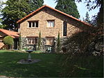
Oregon Iron Company Furnace

1866 establishments in OregonBuildings and structures in Lake Oswego, OregonIndustrial buildings and structures on the National Register of Historic Places in OregonIndustrial buildings completed in 1866Industrial furnaces
National Register of Historic Places in Clackamas County, OregonWikipedia Student Program
Oregon Iron Company Furnace restored

The Oregon Iron Company Furnace, or Oswego Iron Furnace, is an iron furnace used by the Oregon Iron Company, in Lake Oswego, Oregon's George Rogers Park, in the United States. The structure was added to the National Register of Historic Places in 1974 and underwent a major renovation in 2010. The current furnace is the only structure that remains of the original iron company, and is the oldest industrial landmark in the state of Oregon.

Excerpt from the Wikipedia article Oregon Iron Company Furnace (License: CC BY-SA 3.0, Authors, Images).

Oregon Iron Company Furnace
Willamette Greenway,

Geographical coordinates (GPS) Address Nearby Places
placeShow on map

Wikipedia: Oregon Iron Company FurnaceContinue reading on Wikipedia

Geographical coordinates (GPS)

Latitude Longitude
N 45.410983333333 ° E -122.6607 °
placeShow on map

Address

Oregon Iron Company Furnace

Willamette Greenway
97036
Oregon, United States
mapOpen on Google Maps

Oregon Iron Company Furnace restored
Share experience

Nearby Places

Tryon Creek
Tryon Creek

Tryon Creek is a 4.85-mile (7.81 km) tributary of the Willamette River in the U.S. state of Oregon. Part of the drainage basin of the Columbia River, its watershed covers about 6.5 square miles (16.8 km2) in Multnomah and Clackamas counties. The stream flows southeast from the Tualatin Mountains (West Hills) through the Multnomah Village neighborhood of Portland and the Tryon Creek State Natural Area to the Willamette in the city of Lake Oswego. Parks and open spaces cover about 21 percent of the watershed, while single-family homes dominate most of the remainder. The largest of the parks is the state natural area, which straddles the border between the two cities and counties. The bedrock under the watershed includes part of the last exotic terrane, a chain of seamounts, acquired by the North American Plate as it moved west during the Eocene. Known as the Waverly Hills Formation, it lies buried under ash and lava from later volcanic eruptions, sediments from flooding and erosion, and layers of wind-blown silt. Two dormant volcanoes from the Boring Lava Field are in the Tryon Creek watershed. Named for mid-19th century settler, Socrates Hotchkiss Tryon, Sr., the creek ran through forests of cedar and fir that were later logged by the Oregon Iron Company and others through the mid-20th century. Efforts to establish a large park in the watershed began in the 1950s and succeeded in 1975 when the state park was formally established. As of 2005, about 37 percent of the watershed was wooded and supported more than 60 species of birds as well as small mammals, amphibians, and fish. At the same time, the human population was about 18,000.