Lower Rancheria, California
Amador County, California geography stubsFormer populated places in CaliforniaFormer settlements in Amador County, CaliforniaPopulated places established in 1848
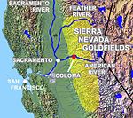
Lower Rancheria is a former gold-mining camp in Amador County, California. It was located on Rancheria Creek 2 miles (3.2 km) east-southeast of Drytown, at an elevation of 1017 feet (310 m). Placer mining began at Lower Rancheria in 1848.Prior to 1855, the camp at Lower Rancheria was mostly populated by Spanish-speaking miners. On 6 August 1855 a series of murders were carried out at the camp by a group of Mexicans, who killed five men and one women and who also robbed the contents of a safe. Following this, three of the Mexicans were hanged, and the Mexican population of the camp were driven away.
Excerpt from the Wikipedia article Lower Rancheria, California (License: CC BY-SA 3.0, Authors).Lower Rancheria, California
Turner Road,
Geographical coordinates (GPS) Address Nearby Places Show on map
Geographical coordinates (GPS)
| Latitude | Longitude |
|---|---|
| N 38.438055555556 ° | E -120.81944444444 ° |
Address
Turner Road
Turner Road
95601
California, United States
Open on Google Maps


