Kunětická hora
Cenozoic magmatismGeography of the Pardubice RegionMountains and hills of the Czech RepublicPardubice District

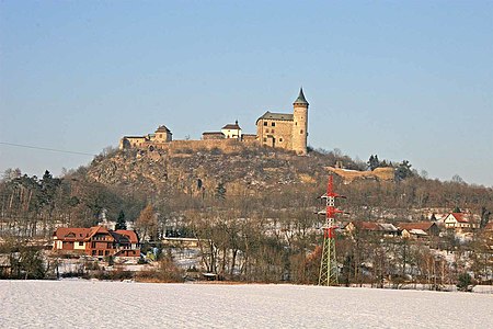
Kunětická hora is a hill in the municipality of Ráby in the Pardubice Region of the Czech Republic, about 6 km north-northeast from the city of Pardubice. Kunětická hora has an elevation of 307 m (1,007 ft) above sea level. It sits in a plain of the East Elbe Table, above which it rises 82 m (269 ft). Geologically, the hill is a laccolith, dating from the Cenozoic era. Toward the end of the 19th century, the slopes of the hill were used as a quarry, at such a pace that the hill was in danger of disappearing. The hill is best known for Kunětická hora Castle, a castle at its summit. A modern water reservoir has been built inside the top part of the hill.
Excerpt from the Wikipedia article Kunětická hora (License: CC BY-SA 3.0, Authors, Images).Kunětická hora
2985, okres Pardubice
Geographical coordinates (GPS) Address Phone number Website Nearby Places Show on map
Geographical coordinates (GPS)
| Latitude | Longitude |
|---|---|
| N 50.08 ° | E 15.812777777778 ° |
Address
Hrad Kunětická Hora
2985
533 52 okres Pardubice, Ráby
Northeast, Czechia
Open on Google Maps


