place

St Augustine's Roman Catholic High School, Billington

1963 establishments in EnglandAcademies in LancashireCatholic secondary schools in the Diocese of SalfordEducational institutions established in 1963Schools in Ribble Valley
Secondary schools in LancashireUse British English from February 2023
St. Augustine's Roman Catholic High School

St Augustine's RC High School is a coeducational Roman Catholic secondary school located in Billington, Lancashire, England.

Excerpt from the Wikipedia article St Augustine's Roman Catholic High School, Billington (License: CC BY-SA 3.0, Authors, Images).

St Augustine's Roman Catholic High School, Billington
Elker Lane, Ribble Valley Billington and Langho

Geographical coordinates (GPS) Address Phone number Website External links Nearby Places
placeShow on map

Wikipedia: St Augustine's Roman Catholic High School, BillingtonContinue reading on Wikipedia

Geographical coordinates (GPS)

Latitude Longitude
N 53.816 ° E -2.427 °
placeShow on map

Address

St Augustine's Roman Catholic High School

Elker Lane
BB7 9JA Ribble Valley, Billington and Langho
England, United Kingdom
mapOpen on Google Maps

Phone number

call+441254823362

Website
sarchs.com

linkVisit website

linkWikiData (Q7592547)
linkOpenStreetMap (51735918)

St. Augustine's Roman Catholic High School
Share experience

Nearby Places

River Hodder
River Hodder

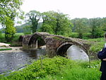
The River Hodder is in Lancashire, England. It is a County Biological Heritage Site. It rises on White Hill and flows for approximately 23 miles to the River Ribble, of which it is the largest tributary. The Hodder drains much of the Forest of Bowland Area of Outstanding Natural Beauty and all but the last mile of its course is through this scenic area. The upper reaches of the river feed the large Stocks Reservoir, which provides water supply to the Fylde coast. After exiting the reservoir, the Hodder continues in a general southward direction. It collects many tributaries from the valleys of Bowland and, lower down, parts of the Ribble Valley. Most notable among the feeders of the Hodder are Croasdale Brook, Easington Brook, the River Dunsop, Langden Brook and the River Loud. Much of the land in the Hodder Valley further to the north is owned by the Crown as Duke of Lancaster, whilst further down, farming land on the Stonyhurst Estate is owned by Stonyhurst College and the Jesuits. The river runs close to the College and passes adjacent to the former preparatory school, Hodder Place. The river lends its name to the pre-preparatory department at Stonyhurst, "Hodder House" and also years three to five known collectively as "Hodder Playroom". The River Hodder eventually joins the River Ribble near Great Mitton, close to the River Calder. The relief of the river starts over 400 m above sea level and within a distance of 15 km it drops to 99 m above sea level. The Lower Hodder marks the historical county boundary between Lancashire and the West Riding of Yorkshire. It formed an important early feature in the development of the ancient Lordship of Bowland.