place

Terry Fox Stadium

Athletics (track and field) venues in OntarioMulti-purpose stadiums in CanadaOttawa stubsSoccer venues in OntarioSports venues in Ottawa
Terry Fox
Terry Fox Stadium, Ottawa

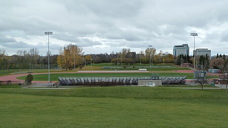
Terry Fox Stadium, also known as the Terry Fox Athletic Facility is an athletic field in Ottawa, Ontario, Canada, named after cancer research activist Terry Fox. It has a regulation-size natural grass soccer field, surrounded by a 400-metre track. Surrounding the track are bleachers with a capacity of approximately 2,000. It is located in Mooney's Bay Park, on the west side of Riverside Drive, south of Heron Road, which is south of downtown Ottawa. The stadium hosted the track and field events at the 2001 Francophone Games. It has hosted the Pan American Combined Events Cup since 2012.

Excerpt from the Wikipedia article Terry Fox Stadium (License: CC BY-SA 3.0, Authors, Images).

Terry Fox Stadium
Riverside Drive, (Old) Ottawa River

Geographical coordinates (GPS) Address Nearby Places
placeShow on map

Wikipedia: Terry Fox StadiumContinue reading on Wikipedia

Geographical coordinates (GPS)

Latitude Longitude
N 45.370307 ° E -75.692185 °
placeShow on map

Address

Riverside Drive
K1V 8N5 (Old) Ottawa, River
Ontario, Canada
mapOpen on Google Maps

Terry Fox Stadium, Ottawa
Share experience

Nearby Places

Mooney's Bay Park
Mooney's Bay Park

Mooney's Bay Park is a public park in Ottawa, Ontario, Canada, on the Rideau River. Its main entrance is on Riverside Drive, opposite Ridgewood Avenue, but can also be accessed from Hog's Back Road. Mooney's Bay Park has a beach, picnic areas, a children's playground, the Sue Holloway Fitness Park, and is the site of the Terry Fox Stadium. Located at 2960 Riverside Drive, year-round activities are available such as swimming in the waters of the Rideau River, biking along paths that can take riders as far as the downtown core, and cross country skiing. A ski school is available, as are indoor change rooms. Since 2012, like all city parks and beaches, Mooney's Bay Park is regulated by a bylaw which prohibits smoking on the entire beach and park property.In the summer, Mooney's Bay Beach is one of the City of Ottawa's four supervised beaches. The city's Parks, Recreation and Cultural Services Department set up a swimming area, which is supervised by trained lifeguards from 12pm-7pm each day, from the third week in June until the third week in August. From mid-May until early September, volleyball nets can be rented per hour or for the day and stand-up paddleboards (SUPs) can be rented by the hour. This can be done from beach and lifeguard staff. After rainfalls, swimming is often prohibited due to excessive bacteria. The City of Ottawa posts water quality results on its websites and signs are posted when swimming is unsafe. Many wedding parties have their photos taken by the arched wooden bridges with weeping willows as a backdrop in the spring and summer months. Mooney's Bay is also home to Pirate Adventures, an interactive pirate-theatre cruise. Baja Burger Shack is a licensed bar and grill at Mooney's Bay. Mooney's Bay Park has been adopted by the Omicron-Pi Chapter of the Kappa Sigma Fraternity.

Hog's Back Falls
Hog's Back Falls

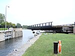
The Hog's Back Falls, officially known as the Prince of Wales Falls, but rarely referred to by this name, are a series of artificial waterfalls on the Rideau River in Ottawa, Ontario, Canada. The falls are located just north of Mooney's Bay and the point where the Rideau Canal splits from the Rideau River. Prior to the construction of the Rideau Canal, these were a gentle set of rapids originally known as Three Rock Rapids. The name Hog's Back came into use shortly before canal construction. Civil Engineer John MacTaggart, in 1827, described them as "a noted ridge of rocks, called the Hog’s Back, from the circumstances of raftsmen with their wares [timber rafts] sticking on it in coming down the stream." These rapids were about 600 metres (2 000 feet) in length with a drop of about 1.8 metres (6 feet). They were navigable by canoe; no portage was required. As part of his concept for a slackwater navigation system, Lt. Colonel John By's design for the Rideau Canal called for a large dam to be raised in this location. It would divert water from the Rideau River into the artificially-created section of the canal leading to the Ottawa locks. It would also flood the Three Island Rapids located upstream (the head of present-day Mooney's Bay marks the foot of these rapids). The building of this dam provided one of the greatest construction challenges (it collapsed three times during construction) of the Rideau Canal, but when completed in 1831, it flooded the Rideau River at that point by 12.5 metres (41 feet). To accommodate the natural flow of the Rideau River and to prevent damage from spring flooding, a large wastewater weir was constructed. The water from this flows through a channel that was excavated in the eastern bank of the Rideau River. This created the Hog's Back Falls that we see today. The head of the original rapids is now buried beneath the canal dam, but the lower section of the rapids can still be seen today. This location marks where the route of the Rideau Canal leaves the Rideau River and enters a manmade canal leading to the Ottawa locks. A series of locks lowers boats from this location to the Ottawa River.

Riverside Park, Ottawa

Riverside Park is a neighbourhood in the south end of Ottawa, Canada. It is bounded on the north by Brookfield Road, on the east by the Airport Parkway, on the south by the CN rail tracks and on the west by the Rideau River. The neighbourhood includes one of Ottawa's most well known beaches at Mooney's Bay and the Terry Fox Athletic Facility, along with both Vincent Massey Park, Hog's Back Park. Confederation Heights sits at the northern tip of the neighbourhood. It also includes the Ottawa Hunt and Golf Club, which has hosted professional and amateur golf tournaments. The area is served by Brookfield High School and the General Vanier, Bayview Public Schools, Georges Étienne Cartier as well as the Holy Cross Catholic School. In addition to Mooney's Bay, the area is served by four other parks; Paget Park, Marble Park, Flannery Park and Pauline Vanier Park, adjacent to General Vanier Public School. In August 2007, Bayview Public School was closed at its site on Riverside drive. Its French immersion program moved to the R. Byrns Curry Public School building (renamed Bayview Public School). R. Byrns Curry students were reassigned to General Vanier Public School (J-K to grade 3) and Fielding Drive Public School (grades 4 to 8).The neighbourhood is bifurcated by OCRR Railway. The area west of it is known as Riverside Park West and the area east of it is called Riverside Park East. The area to the south of Walkley Road is known as Riverside Park South. According to the Canada 2011 Census, the population of the neighbourhood north of Walkley (Census Tract 5050003.00) was 4564 and south of Walkley (Census Tract 5050002.01) was 2893 for a total of 7457.