Andhra Pradesh (English: , Telugu: [aːndʱrɐ prɐdeːʃ] abbr. AP) is a state in the southern coastal region of India. It is the seventh-largest state with an area of 162,970 km2 (62,920 sq mi) and the tenth-most populous state with 49,577,103 inhabitants. It has shared borders with Chhattisgarh, Odisha, Karnataka, Tamil Nadu, Telangana and the Bay of Bengal. It has the second-longest coastline in India at about 974 km (605 mi). After existence as Andhra State and unified Andhra Pradesh, the state took its present form on 2 June 2014, when the new state of Telangana was formed through bifurcation. Amaravati is the capital of the state, with the largest city being Visakhapatnam. Telugu, one of the classical languages of India used by the majority of people, is the first official language.
As per the 8th century BCE Rigvedic text Aitareya Brahmana, the Andhras left North India off the banks of the Yamuna river and migrated to South India. In the third century BCE, Andhra was a vassal kingdom of Ashoka of the Mauryan Empire. After his death, it became powerful and extended its empire to the whole Maratha country and beyond under the rule of the Satavahana dynasty. After that, the major rulers included the Pallavas, Eastern Chalukyas, Kakatiyas, Vijayanagara Empire, Qutb Shahi dynasty, Nizam dynasty, East India Company, and British Raj.
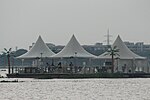
The Eastern Ghats are a major dividing line separating coastal plains and peneplains. The coastal plains are part of Coastal Andhra. These are mostly delta regions formed by the Krishna, Godavari, and Penna rivers. Peneplains are part of Rayaaseema. 60% of the population is engaged in agriculture and related activities. Rice is the state's major food crop and staple food. The state contributes 10% of total fish production and over 70% of shrimp production in India. Industry sectors such as food products, non-metallic minerals, textiles, and pharmaceuticals are the top employment providers. The automotive sector accounts for 10% of India's auto exports. The state has about one-third of India's limestone reserves, large deposits of baryte and galaxy granite, and reserves of oil and natural gas. Satish Dhawan Space Centre (SDSC), known as Sriharikota Range (SHAR), at the barrier island of Sriharikota in Tirupati district, is the satellite launching station of India.
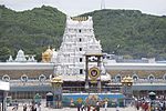
Some of the unique products from the state are Banaganapalle mangoes, Bandar laddu, Kondaplli toys, Tirupati laddu, and saris made in Dharmavaram and Machilipatnam. Kuchipudi is the official dance form. Many composers of Carnatic music, like Annamacharya, Kshetrayya, and Tyagaraja, were from this region. The Tirumala Venkateswara temple near Tirupati is the most visited Hindu religious place in the world. The state is home to a variety of other pilgrimage centres and natural attractions.

 Continue reading on Wikipedia