place

Museums in Basel

Museums in Basel
Basel Museum Wegweiser

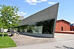
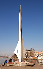
The Basel museums encompass a series of museums in the city of Basel, Switzerland, and the neighboring region. They represent a broad spectrum of collections with a marked concentration in the fine arts and house numerous holdings of international significance. With at least three dozen institutions, not including the local history collections in the surrounding communities, the region offers an extraordinarily high density of museums compared to other metropolitan areas of similar size. They draw some one and a half million visitors annually. Constituting an essential and defining component of Basel culture and cultural policy, the museums are the result of closely interwoven private and public collecting activities and promotion of arts and culture going back to the 16th century. The public museums of the canton of Basel-City arose from the 1661 purchase of the private Amerbach Cabinet by the city and the University of Basel and thus represent the oldest civic museum collection in continuous existence. Since the 1980s, a number of collections have been made public in new purpose-built structures that have achieved renown as acclaimed examples of avant-garde museum architecture.

Excerpt from the Wikipedia article Museums in Basel (License: CC BY-SA 3.0, Authors, Images).

Museums in Basel
Colmarer Straße,

Geographical coordinates (GPS) Address Nearby Places
placeShow on map

Wikipedia: Museums in BaselContinue reading on Wikipedia

Geographical coordinates (GPS)

Latitude Longitude
N 47.6 ° E 7.6 °
placeShow on map

Address

Colmarer Straße

Colmarer Straße
79576 , Friedlingen
Baden-Württemberg, Germany
mapOpen on Google Maps

Basel Museum Wegweiser
Share experience

Nearby Places

Induced seismicity in Basel

Induced seismicity in Basel led to suspension of its hot dry rock enhanced geothermal systems project. A seismic-hazard evaluation was then conducted, resulting in the cancellation of the project in December 2009. Basel, Switzerland sits atop a historically active fault and most of the city was destroyed in a magnitude 6.5 earthquake in 1356. But the Basel project, although it had established an operational approach for addressing induced earthquakes, had not performed a thorough seismic risk assessment before starting geothermal stimulation.Seismic events in Basel reached the trip point of Richter Magnitude ML  2.9 six days after the main stimulation was started on December 2, despite precautionary reduction of the injection rate earlier that same day upon reaching earlier "soft" thresholds. However, further tremors exceeding magnitude 3 were recorded on 6 January (measuring 3.1), 16 January 2007 (3.2), and 2 February 2007 (3.2).In all, between December 2006 and March 2007, the six borehole seismometers installed near the Basel injection well recorded more than 13,500 potential events connected with the geothermal project. The 200 largest were between magnitudes 0.7 and 3.4. Nine of these events had an ML  of 2.5 or larger. The remainder were too small to be observed or felt at the surface. Between December 2 and January 24, 168 seismic events with magnitude greater than 0.6 occurred within 1 km of the wellbore, at depths of 4–5 km, near the well bottom.On 8 December 2006, only 6 days after the main stimulation started on 2 December, the HDR project in Basel was suspended when an earthquake tripped a 4-level "traffic light" scheme established for halting operations in the event of unacceptable induced earthquake occurrences. Trip points of Richter magnitudeML  2.9 and a peak ground velocity of 5 millimeters per second were established by the project as independent criteria for a "red alert" that entailed halting fluid injection and bleeding-off to minimum wellhead pressure. Lesser operational curtailments were triggered for lower magnitude and peak ground velocity thresholds. Earlier that day, a "yellow alert"—the second level—was called at 03:06 local time after a 2.6 ML  event with peak ground velocity of 0.55 mm/s, which exceeded the "soft" 2.3 ML  and 0.5 mm/s thresholds. As a precaution, the injection rate was reduced at 04:04.Following further events that were larger than 2.0ML , a level-three "orange alert" was declared—the injection was stopped at 11:34 and the well shut-in, maintaining the pressure. However, a 2.7 ML  event occurred at 15:46, followed by a 3.4 ML  event at 16:48, and so in accordance with the response strategy, the well was bled off as soon as practicable.The largest event prompted concern from local residents. The six borehole seismometers installed near the Basel injection well to monitor the natural background seismicity and the geothermal stimulation recorded more than 13,500 potential events connected with the geothermal project, from which 3,124 were of sufficient quality to permit [hypocenter] determinations in the period 2–12 December 2006, which spanned the main stimulation and the decline in the event rate. During the post-stimulation period from 13 December 2006 onward, a further 350 locatable events were detected up to 2 May 2007, by which time events were occurring sporadically at around one per day. In all, locations for more than 3,500 events were determined. Of these more than 3,500 events, only the 200 largest (magnitudes between 0.7 and 3.4) were also observed by the earthquake networks of the Swiss Seismological Service and the Seismological Service of Baden-Wuerttemberg, The remainder were too small to be observed or felt at the surface. For the period through 24 January 2007, there were 168 earthquakes with magnitudes> 0.6, 15 with ML  >2, and three withML  > 3. All of these were within 1 km of the wellbore, and at depths between 4 and 5 km, near the well bottom. There were only 9 events with an ML  of 2.5 or larger in the borehole vicinity for the period through 2007. Five occurred in December 2006, two in January 2007, and one each February and March.Damage claims arose from the largest of the events. Eventually, some 2,700 claims were processed by the project's insurer for an estimated 7 million – 9 million Swiss francs (about 6.5 million to 8.3 million U.S dollars)Following a three-year study, the Basel HDR project canceled in December 2009. The study predicted that the town would have continued to experience small earthquakes a few times a year over the 30-year lifetime of the project. The USA soon reacted with new regulations on deep geothermal energy projects.

Siege of Hüningen (1796–1797)

In the siege of Hüningen (27 November 1796 – 1 February 1797), the Austrians captured the city from the French. Hüningen is in the present-day Department of Haut-Rhin, France. Its fortress lay approximately 2.5 miles (4.0 km) north of the Swiss city of Basel and .5 miles (0.80 km) north of the spot where the present-day borders of Germany, France and Switzerland meet. During the time of this siege, the village was part of the Canton of Basel City and the fortress lay in area contested between the German states and the First French Republic. The siege occurred within the French Revolutionary Wars during which Revolutionary France ranged itself against a Coalition that included most of the states with which it shared land or water borders. In particular, France was at odds with the European monarchies, who initially feared for the safety of Louis XVI and his wife, who was the sister of the Holy Roman Emperor. Fighting, which began in 1792, had been inconclusive. Fighting in 1795 had largely favored the Coalition; the Campaign in the Rhineland in 1796, though, had pushed the Coalition forces far into the German states; the Coalition forces had pushed back and, at the end of the summer's fighting in 1796, the Austrian force under command of Archduke Charles had succeeded in pushing the French back to the Rhine. With the conclusion of the Battle of Schliengen on 24 October, the French army withdrew south and west toward the Rhine. Forces commanded by Jean Charles Abbatucci and Pierre Marie Barthélemy Ferino provided the rear guard support and the main force retreated across the Rhine into France. The French retained control of the fortifications at Kehl and Hüningen and, more importantly, the tête-du-ponts (bridgeheads) of the star-shaped fortresses where the bridges crossed the Rhine. The French chief commander, Jean Victor Moreau, offered an armistice to the Austrian commander, which the archduke was inclined to accept. He wanted to secure the Rhine crossings and then send troops to northern Italy to relieve Dagobert Sigmund von Wurmser at besieged Mantua; an armistice with Moreau would allow him to do that. However, his brother, Francis II, the Holy Roman Emperor, and the civilian military advisers of the Aulic Council categorically refused such an armistice, forcing Charles to order simultaneous sieges at Kehl and Hüningen. These tied his army to the Rhine for most of the winter. He himself moved north with the bulk of his force to invest the larger crossing at Kehl, and instructed Karl Aloys zu Fürstenberg to conduct the siege in the south by Basel. While the Austrians besieged these Rhine crossings, Moreau had sufficient surplus troops to send 14 demi-brigades (approximately 12,000 troops) into Italy to assist in the siege at Mantua.Fürstenberg's force initiated the siege within days of the Austrian victory at the Battle of Schliengen. Most of the siege ran concurrently with the siege at Kehl, which concluded on 9 January 1797. By the time troops engaged at Kehl marched to Hüningen in preparation for a major assault, Fürstenberg had established extensive earthworks, built three large batteries that rained continuous cannonades into the fortress. The Habsburgs repelled a French sortie in early December in which Abbatucci, the French commander, was killed. His replacement, Georges Joseph Dufour, capitulated on 1 February 1797, preventing a costly assault, and the French evacuated, taking everything of value that remained with them. Like the conclusion of the siege at Hüningen, the Austrians took possession of a pile of rubble.