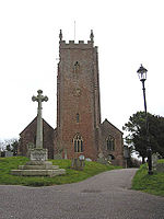
Langford Budville
Civil parishes in SomersetGrand Western CanalUse British English from December 2018Villages in Taunton Deane

Langford Budville is a village and civil parish in Somerset, England, situated near the River Tone 2 miles (3.2 km) north-west of Wellington, 4.5 miles (7.2 km) from Wiveliscombe and 6 miles (9.7 km) west of Taunton. The parish includes the hamlets of Bindon, Lower Chipley, Lower Wellisford, Ramsey and Runnington. The parish has a population of 535.Langford Budville has a few basic facilities; like most villages it has a church (St Peter's), a public house (The Martlet), and a school (Langford Budville Church of England Primary) There is also a hotel.
Excerpt from the Wikipedia article Langford Budville (License: CC BY-SA 3.0, Authors, Images).Langford Budville
Langford Budville Road,
Geographical coordinates (GPS) Address Nearby Places Show on map
Geographical coordinates (GPS)
| Latitude | Longitude |
|---|---|
| N 50.9989 ° | E -3.2669 ° |
Address
Langford Budville Road
TA21 0RB
England, United Kingdom
Open on Google Maps


