Oberhohenberg
Baden-Württemberg geography stubsMountains and hills of the Swabian JuraOne-thousanders of Germany

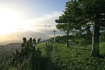
The Oberhohenberg (1,011 metres) is the second highest mountain of the Swabian Alb, only four metres lower than the Lemberg. It is one of the "ten thousanders." The ruins on its top derive from the year 1449, when Oberhohenberg Castle together with the town of Hohenberg, at the foot of the mountain, were destroyed in a local feud.
Excerpt from the Wikipedia article Oberhohenberg (License: CC BY-SA 3.0, Authors, Images).Oberhohenberg
Am Sturmbühl, Gemeindeverwaltungsverband Heuberg
Geographical coordinates (GPS) Address Nearby Places Show on map
Geographical coordinates (GPS)
| Latitude | Longitude |
|---|---|
| N 48.163888888889 ° | E 8.7605555555556 ° |
Address
Ruine Oberhohenberg
Am Sturmbühl
78559 Gemeindeverwaltungsverband Heuberg
Baden-Württemberg, Germany
Open on Google Maps


