Žitný ostrov

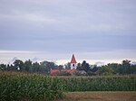
Žitný ostrov (lit. 'Rye Island'), also called Veľký Žitný ostrov (lit. 'Great Rye Island'; German: Große Schüttinsel, lit. 'Great Schütt Island', Hungarian: Csallóköz) to differentiate it from Malý Žitný ostrov (lit. 'Small Rye Island'; German: Kleine Schüttinsel, lit. 'Little Schütt Island'; Hungarian: Szigetköz), is a river island in southwestern Slovakia, extending from Bratislava to Komárno. It lies between the Danube, its tributary Little Danube and Váh. The island is a major part of the Danubian Flat. It is the biggest river island in Europe, with an area of 1,886 km2 (728 sq mi), measuring 84 km (52 mi) in length and 15 to 30 km (9.3 to 18.6 mi) in width. The main towns on the island are Komárno, Dunajská Streda and Šamorín. Two boroughs of Bratislava, Vrakuňa and Podunajské Biskupice, are also located on the island. The Slovnaft refinery is also located on the island. The island is the biggest drinking water reservoir in Slovakia, and one of the biggest in Europe as well. Because of its warm climate, good soils and water reservoirs it is an important agricultural region, with the best conditions for crop production. It is the most fertile region in Slovakia, causing the majority of the island to be deforested. Southern parts of Žitný ostrov by the Danube are protected by Dunajské luhy Protected Landscape Area.
Excerpt from the Wikipedia article Žitný ostrov (License: CC BY-SA 3.0, Authors, Images).Žitný ostrov
Geographical coordinates (GPS) Address Nearby Places Show on map
Geographical coordinates (GPS)
| Latitude | Longitude |
|---|---|
| N 47.95 ° | E 17.65 ° |
Address
930 14 (Mad)
Region of Trnava, Slovakia
Open on Google Maps


