1812 Caracas earthquake
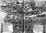
The 1812 Caracas earthquake took place in Venezuela on March 26 (on Maundy Thursday) at 4:37 p.m. It measured 7.7 on the Richter magnitude scale. It caused extensive damage in Caracas, La Guaira, Barquisimeto, San Felipe, and Mérida. An estimated 15,000–20,000 people perished as a result, in addition to incalculable material damage.The seismic movement was so significant that in a zone named Valecillo, a new lake was formed and the river Yurubí was dammed up. Numerous rivulets changed their course in the Caracas valley, which was flooded with dirty water.Based on contemporary descriptions, the earthquake is believed to have consisted of two seismic shocks occurring within the span of 30 minutes. The first destroyed Caracas and the second Mérida, where it was raining when the shock occurred.
Excerpt from the Wikipedia article 1812 Caracas earthquake (License: CC BY-SA 3.0, Authors).1812 Caracas earthquake
Avenida Isabel La Católica,
Geographical coordinates (GPS) Address Nearby Places Show on map
 Continue reading on Wikipedia
 Geographical coordinates (GPS)
| Latitude | Longitude |
|---|---|
| N 10.6 ° | E -66.9 ° |
Address
Avenida Isabel La Católica
Avenida Isabel La Católica
1164 , Parroquia Macuto (Municipio Vargas)
Venezuela
Open on Google Maps