place

Qumran

1851 archaeological discoveries60s disestablishments in the Roman EmpireAll accuracy disputesAncient Jewish settlements of JudaeaArchaeological sites in the West Bank
Dead Sea ScrollsEstablishments in the Hasmonean KingdomFormer populated places in Southwest AsiaJews and Judaism in the Roman EmpireNational parks of IsraelNature reserves in Israeli-occupied territoriesNature reserves in PalestinePopulated places disestablished in the 1st centuryPopulated places established in the 2nd century BCQumranTourist attractions in the West BankWikipedia extended-confirmed-protected pages
Kumeran4
Kumeran4

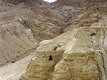
Qumran (Hebrew: קומראן; Arabic: خربة قمران Khirbet Qumran) is an archaeological site in the West Bank managed by Israel's Qumran National Park. It is located on a dry marl plateau about 1.5 km (1 mi) from the northwestern shore of the Dead Sea, about 10 km (6 mi) south of the historic city of Jericho, and adjacent to the modern Israeli settlement and kibbutz of Kalya. The Hellenistic period settlement was constructed during the reign of Hasmonean leader John Hyrcanus (134–104 BCE) or somewhat later. Qumran was inhabited by a Jewish sect of the late Second Temple period, which most scholars identify with the Essenes; however, other Jewish groups were also suggested. It was occupied most of the time until 68 CE and was destroyed by the Romans during the First Jewish–Roman War, possibly as late as 73 CE. It was later used by Jewish rebels during the Bar Kokhba revolt. Today, the Qumran site is best known as the settlement nearest to the Qumran Caves where the Dead Sea Scrolls were hidden, caves in the sheer desert cliffs and beneath, in the marl terrace. The principal excavations at Qumran were conducted by Roland de Vaux in the 1950s, and several later digs have been carried out. Since the 1967 Six-Day War, Qumran has been managed by the Israel Nature and Parks Authority.

Excerpt from the Wikipedia article Qumran (License: CC BY-SA 3.0, Authors, Images).

Qumran
מעלה קומראן, Megilot Yam HaMelakh Regional Council

Geographical coordinates (GPS) Address External links Nearby Places
placeShow on map

Wikipedia: QumranContinue reading on Wikipedia

Geographical coordinates (GPS)

Latitude Longitude
N 31.740833333333 ° E 35.458611111111 °
placeShow on map

Address

קומראן

מעלה קומראן
Megilot Yam HaMelakh Regional Council
Judea and Samaria, Palestinian Territories
mapOpen on Google Maps

linkWikiData (Q223399)
linkOpenStreetMap (611895589)

Kumeran4
Kumeran4
Share experience

Nearby Places

Inn of the Good Samaritan

The Inn of the Good Samaritan is a national park, museum, ancient archaeological site and former inn administered by the Israel Nature and Parks Authority located near Ma'ale Adumim, halfway between Jerusalem and Jericho, at an elevation of 298 meters above sea level.The Inn is named after the New Testament's Parable of the Good Samaritan, and houses a museum of ancient mosaics and other archaeological findings mostly dating from the 4th-7th centuries that were collected from churches and Jewish and Samaritan synagogues from the West Bank and from the ancient Gaza synagogue. Beginning in biblical times, Jewish pilgrims from the Galilee took the nearby Jerusalem-Jericho road to worship at the Temple in Jerusalem. In later times, Christian pilgrims used the road to reach the baptismal site of Jesus on the Jordan River, near Jericho. The area of the Inn of the Good Samaritan was repeatedly fortified, and traveller-inns were built a little below the hilltop. This is reflected in the presence of two distinct, if related, archaeological sites in close proximity to each other, the other site being the ruins of a castle believed to have been built by King Herod although today they are separated by the modern Jerusalem–Jericho highway. Today, the Inn of the Good Samaritan is a mosaic museum, and serves as a tourist attraction visited especially by international tourists, particularly Christians. The museum features a guided audio tour, and is accessible to persons with disabilities.