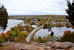
Rideau River

The Rideau River (French: Rivière Rideau, Ojibwe: Pasapkedjinawong) is a river in Eastern Ontario, Canada. The river flows north from Upper Rideau Lake and empties into the Ottawa River at the Rideau Falls in Ottawa, Ontario. Its length is 146 kilometres (91 mi). As explained in a writing by Samuel de Champlain in 1613, the river was given the name "Rideau" (French for 'curtain') because of the appearance of the Rideau Falls. The Anishinàbemowin name for the river is Pasapkedjinawong, 'the river that passes between the rocks'. The Rideau Canal, which allows travel from Ottawa to the city of Kingston, Ontario on Lake Ontario, was formed by joining the Rideau River with the Cataraqui River. The river diverges from the Canal at Hog's Back Falls in Ottawa. In early spring, to reduce flooding on the lower section of the river, workers from the city of Ottawa use ice blasting to clear the ice which covers the river from Billings Bridge to Rideau Falls by cutting "keys" through the ice and using explosives to break off large sheets of ice. This practice has been going on for more than 100 years. The regulatory authority charged with protecting the Rideau River and its tributaries is the Rideau Valley Conservation Authority.
Excerpt from the Wikipedia article Rideau River (License: CC BY-SA 3.0, Authors, Images).Rideau River
Rideau Lakes
Geographical coordinates (GPS) Address Nearby Places Show on map
Geographical coordinates (GPS)
| Latitude | Longitude |
|---|---|
| N 44.682 ° | E -76.336 ° |
Address
Newboro
K0G 1P0 Rideau Lakes
Ontario, Canada
Open on Google Maps


