Alouette Lake

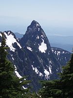
Alouette Lake, originally Lillooet Lake and not to be confused with the lake of that name farther north, is a lake and reservoir in Maple Ridge, British Columbia, Canada. It is located at the southeast foot of the mountain group known as the Golden Ears and is about 16 km in length on a northeast–southwest axis. It and the Alouette River, formerly the Lillooet River, were renamed in 1914 to avoid confusion with the larger river and lake farther north, with "Alouette", the French word for "lark", being chosen as being melodious and reminiscent of the original name in tone. Most of the basin of Alouette Lake has never been logged and its north flank is protected as part of Golden Ears Provincial Park (formerly part of Garibaldi Provincial Park until that park's division). A small portion of the lake and its largely inaccessible northwestern shore, near its narrows, are actually part of the District of Mission due to the rectangular shape of that district's boundary. North of the portion of the lake that is in Mission, the rest of its northern end is not in either municipality.
Excerpt from the Wikipedia article Alouette Lake (License: CC BY-SA 3.0, Authors, Images).Alouette Lake
Maple Ridge
Geographical coordinates (GPS) Address Website Nearby Places Show on map
Geographical coordinates (GPS)
| Latitude | Longitude |
|---|---|
| N 49.333333333333 ° | E -122.41666666667 ° |
Address
Maple Ridge
Maple Ridge
British Columbia, Canada
Open on Google Maps


