place

Lemon Stream (Sandy River tributary)
Maine river stubsRivers of Franklin County, MaineRivers of MaineRivers of Somerset County, MaineTributaries of the Kennebec River
Solstice 2007 resiz
Solstice 2007 resiz

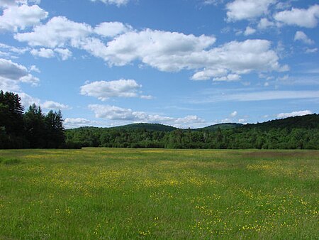
Lemon Stream is a 15.2-mile-long (24.5 km) tributary of the Sandy River, that rises in the New Vineyard mountain range in Franklin County, Maine, USA. Via the Sandy River, it is part of the Kennebec River watershed. The source of Lemon Stream is a spring located 1,460 feet (450 m) above sea level between Little Mountain and Caswell Mountain. It flows southeasterly across the northeast corner of Industry, enters Somerset County through the southwest corner of Anson, and then meets the larger Sandy River which forms the southern boundary of Starks. It is not to be confused with the deeply shadowed north-flowing brook in New Portland, Maine of the same name. Lemon Stream flows from upper level wetlands on the southeastward slopes of the New Vineyard mountains, drops over numerous falls into the fields of upper Lemon Stream valley, then moves south through the sugar maple woodlands into the lower Lemon Stream valley. Here it widens and slows behind a small hydroelectric dam in Starks. Below the dam it snakes further south through more woods and farmland until the shifting sands of its delta yields to the eastward flowing Sandy River.

Excerpt from the Wikipedia article Lemon Stream (Sandy River tributary) (License: CC BY-SA 3.0, Authors, Images).

Lemon Stream (Sandy River tributary)
Sandy River Road,

Geographical coordinates (GPS) Address Nearby Places
placeShow on map

Wikipedia: Lemon Stream (Sandy River tributary)Continue reading on Wikipedia

Geographical coordinates (GPS)

Latitude Longitude
N 44.7117 ° E -69.9165 °
placeShow on map

Address

Sandy River Road

Sandy River Road

Maine, United States
mapOpen on Google Maps

Solstice 2007 resiz
Solstice 2007 resiz
Share experience

Nearby Places

Battle of Norridgewock

The Battle of Norridgewock was a raid on the Abenaki settlement of Norridgewock by a group of colonial militiamen from the New England Colonies. Occurring in contested lands on the edge of the American frontier, the raid resulted in a massacre of the Abenaki inhabitants of Norridgewock by the militiamen. The raid was undertaken to check Abenaki power in the region, limit Catholic proselytizing among the Abenaki (and thereby perceived French influence), and to allow the expansion of New England settlements into Abenaki territory and Acadia. New France defined this area as starting at the Kennebec River in southern Maine.: 27  Other motivations for the raid included the special £100 scalp bounty placed on Râle's head by the Massachusetts provincial assembly and the bounty on Abenaki scalps offered by the colony during the conflict. Captains Johnson Harmon, Jeremiah Moulton, and Richard Bourne (Brown) led a force of two hundred colonial New Englanders, which attacked the Abenaki village of Narantsouak, or Norridgewock, on the Kennebec River; the current town of Norridgewock, Maine developed near there. The village was led by, among others, the sachems Bomazeen and Welákwansit, known to the English as Mog. The village's Catholic mission was run by a French Jesuit priest, Father Sébastien Râle.Casualties, depending on the sources consulted, vary, but most accounts record about eighty Abenaki being killed. But both English and French accounts agree that the raid was a surprise nighttime attack on a civilian target, and they both also report that many of the dead were unarmed when they were killed, and those massacred included many women and children. As a result of the raid, New Englanders flooded into the lower Kennebec region, establishing settlements there in the wake of the war.

Thompson's Bridge
Thompson's Bridge

Thompson's Bridge is a historic stone bridge in rural Franklin County, Maine. Built c. 1808, it is one of a very small number of surviving stone lintel bridges in the state, a type that were once quite common. It carries a local dirt road across Josiah Creek in the Allen's Mills section of Industry, and is located near (and possibly on) the border with neighboring Somerset County. The bridge was listed on the National Register of Historic Places in 1991.The bridge abutments consist of local fieldstone arranged in dry laid courses. The main span consists of large granite slabs laid across the narrow opening between the abutments. A layer of earth is built above these slabs, supporting the dirt roadway, which is about 10 feet (3.0 m) wide. The southern abutment has extensive wingwalls, giving that structure a total width of about 20 feet (6.1 m).The road which the bridge carries was probably laid out in 1808, during the early period of Industry's settlement. John Thompson had a house and established a grist mill nearby in 1805. The area had been abandoned by the late 19th century, and the roadway south of the bridge is unmaintained and in deteriorated condition. In a 1924 survey, the state identified more than 100 of this type of bridge; as of 1987, only three were known to survive in relatively unaltered condition. The bridge is also one of the town of Industry's oldest structures; its oldest surviving building has an estimated construction date of 1820.