Ring Mountain (California)

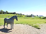
Ring Mountain is an elevated landform on the Tiburon Peninsula in Marin County, California. This mountain was named for George E. Ring, who served as a Marin County Supervisor from 1895 to 1903.A number of rare and endangered flora inhabit Ring Mountain. The mountain's twin summits consist of serpentinite, a rock which is very high in magnesium, producing soils of unusual chemistry (serpentine soil). The landscape is strewn with many sizable boulders which exhibit a variety of lithologies including high-pressure metamorphic rocks of amphibolite, blueschist, greenschist, and eclogite grade.Native American pecked curvilinear nucleated petroglyphs created by the Coast Miwok people are also found here.
Excerpt from the Wikipedia article Ring Mountain (California) (License: CC BY-SA 3.0, Authors, Images).Ring Mountain (California)
Ring Mountain Fire Road,
Geographical coordinates (GPS) Address Nearby Places Show on map
Geographical coordinates (GPS)
| Latitude | Longitude |
|---|---|
| N 37.909691528 ° | E -122.485779814 ° |
Address
Ring Mountain Fire Road
Ring Mountain Fire Road
94920
California, United States
Open on Google Maps


