place

Lookout Place

1776 in the United StatesBuildings and structures in Staten IslandNew York (state) in the American RevolutionUse mdy dates from October 2011Wikipedia references cleanup from May 2016
Lookoutfort
Lookoutfort

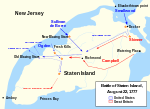
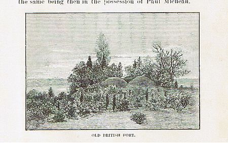
Lookout Place or Fort Hill (also known as Fort Izard) was an American Revolutionary War British garrison, or earthen mound-fortress roughly 44 feet square at the top of La Tourette Hill in Historic Richmondtown, Staten Island, New York. The redoubt was constructed in 1776 by British Regulars during the occupation of Richmond County. General William Howe planned his successful capture of New York City while encamped on the Island, along with 30,000 British and Hessian soldiers joining to suppress the rebellion after the arrival of his brother Admiral Richard Howe. The fort overlooked a fresh water spring about 200 feet directly below (known as the Lord Howe Spring), the Old Mill Road, Fresh Kills which is a tributary of Richmond Creek, St. Andrews Church and the town of Richmond, then referred to as Cuckoldstown, in the valley just below La Tourette Hill. The hilltop was widely denuded of trees by the British during the war, allowing the soldiers to have unobstructed views of Lower New York Bay and the Arthur Kill. It is now the La Tourette Golf Course. Extensive archeological digs have taken place at the beginning of the 20th century, revealing all manner of British accuetrament, from remnants of weaponry to soldier coat buttons, shoe buckles and pottery fragments.Robert Rogers created a new unit while encamped at Richmondtown called The Queen's Rangers named after Charlotte, wife of King George III.

Excerpt from the Wikipedia article Lookout Place (License: CC BY-SA 3.0, Authors, Images).

Lookout Place
London Road, New York Staten Island

Geographical coordinates (GPS) Address Nearby Places
placeShow on map

Wikipedia: Lookout PlaceContinue reading on Wikipedia

Geographical coordinates (GPS)

Latitude Longitude
N 40.58061 ° E -74.14599 °
placeShow on map

Address

London Road
10306 New York, Staten Island
New York, United States
mapOpen on Google Maps

Lookoutfort
Lookoutfort
Share experience

Nearby Places

Staten Island Light
Staten Island Light

The Staten Island Range Light, also known as the Ambrose Channel Range Light, is the rear range light companion to the West Bank Lighthouse. Built in 1912, the 90-foot tower sits more than five miles northwest of the West Bank Lighthouse, on Staten Island’s Richmond Hill (Lighthouse Hill), 141 feet above sea level. It shows a fixed white light that can be seen for 18 miles, by all vessels bound to New York and New Jersey Ports coming in from the Atlantic Ocean (on range only).The original hardware, including the second magnitude Fresnel lens and glass reflector, remain in place. However, the original mineral oil-burning lamp has since been replaced with a 1000 watt General Electric-manufactured Airway Signal incandescent lamp, with the backup light, which automatically turns on in the event of primary lamp failure, being the same. Many lighthouses have transitioned to LED systems, but this legacy equipment remains in use at this light. The Staten Island Range Light also has a second light, the Swash Channel Rear Light. This light is also a steady white light beacon, and shines continuously 24 hours a day. The Swash Channel is not a major shipping lane like the Ambrose Channel. Rather, it is akin to a "secondary road," connecting the Ambrose Channel with the Sandy Hook Channel. This secondary light is not within the lantern room, as is the main light, the Rear Ambrose Channel Light. Both the Ambrose Channel Light, as well as the Swash Channel Light, have backup lights independent from each of the main lighting systems (and the main systems' backup lamps). Neither light blinks or rotates, and each is only visible on range. Additionally, the Staten Island Range Light may be powered by banks of on-site batteries in the event of power failure.It was designated a New York City Landmark in 1968 and remains a valuable aid to navigation for ships entering the Ambrose Channel in Lower New York Bay. It was listed on the National Register of Historic Places in 2005.

Staten Island
Staten Island

Staten Island ( STAT-ən) is the southernmost borough of New York City, coextensive with Richmond County and situated at the southern tip of the U.S. state of New York. The borough is separated from the adjacent state of New Jersey by the Arthur Kill and the Kill Van Kull and from the rest of New York by New York Bay. With a population of 495,747 in the 2020 Census, Staten Island is the least populated New York City borough but the third largest in land area at 58.5 sq mi (152 km2); it is also the least densely populated and most suburban borough in the city. A home to the Lenape indigenous people, the island was settled by Dutch colonists in the 17th century. It was one of the 12 original counties of New York state. Staten Island was consolidated with New York City in 1898. It was formerly known as the Borough of Richmond until 1975, when its name was changed to Borough of Staten Island. Staten Island has sometimes been called "the forgotten borough" by inhabitants who feel neglected by the city government.The North Shore—especially the neighborhoods of St. George, Tompkinsville, Clifton, and Stapleton—is the island's most urban area. It contains the designated St. George Historic District and the St. Paul's Avenue-Stapleton Heights Historic District, which feature large Victorian houses. The East Shore is home to the 2+1⁄2-mile (4-kilometer) FDR Boardwalk, the world's fourth-longest boardwalk. The South Shore, site of the 17th-century Dutch and French Huguenot settlement, developed rapidly beginning in the 1960s and 1970s and is now mostly suburban. The West Shore is the island's least populated and most industrial part. Motor traffic can reach the borough from Brooklyn by the Verrazzano-Narrows Bridge and from New Jersey by the Outerbridge Crossing, Goethals Bridge and Bayonne Bridge. Staten Island has Metropolitan Transportation Authority (MTA) bus lines and an MTA rapid transit line, the Staten Island Railway, which runs from the ferry terminal at St. George to Tottenville. Staten Island is the only borough not connected to the New York City Subway system. The free Staten Island Ferry connects the borough to Manhattan across New York Harbor. It provides views of the Statue of Liberty, Ellis Island, and Lower Manhattan.

Jacques Marchais Museum of Tibetan Art

The Jacques Marchais Museum of Tibetan Art is a museum located on the residential Lighthouse Hill in Egbertville, Staten Island, New York City. It is home to one of the United States' most extensive collections of Himalayan artifacts. The museum was created by Jacques Marchais, (1887-1948) an American woman, to serve as a bridge between the West and the rich ancient and cultural traditions of Tibet and the Himalayan region. Marchais designed her educational center to be an all-encompassing experience: it was built to resemble a rustic Himalayan monastery with extensive terraced gardens and grounds and a fish and lotus pond. The museum was praised for its authenticity by the Dalai Lama, who visited in 1991. In 2009, the site was listed on the New York State Register and National Register of Historic Places. A writer in the New York Times referred to the museum's founder under the name Jacqueline Klauber, noting that she used Marchais as her professional name. Jacques Marchais Coblentz was born in 1887 in Cincinnati, Ohio. After a career as a child actress in Chicago she went to Boston and married at age 16, had three children, and divorced in 1910. After a brief second marriage, she moved to New York City, returned to acting, and associated with people who were interested in Eastern religions and Buddhism. About 1920 she married the owner of a chemical factory and they lived in the rural Staten Island. There, she began collecting. She opened an art gallery in Manhattan in 1938. In 1945 she opened a research library next to her home in Staten Island.Marchais had never visited Tibet or the Himalayas, but she had a lifelong interest in the region and sought to find a permanent home for her collection. The museum officially opened in 1947. The museum, its collection and its history in Staten Island has been chronicled in a book by the same name and 60th anniversary exhibition.The museum has not been able to benefit from the Department of Transportation's initiative to draw traffic to the borough's cultural organizations via a new signage program because it lacks a dedicated parking lot and as such it remains somewhat hidden among New York City's cultural organizations. Bicycling clubs, however, having easier parking, make it a destination.