place

A4 road (Latvia)

All pages needing cleanupEurope road stubsInfobox road instances in LatviaLatvia geography stubsLatvia transport stubs
Roads in Latvia
Road A4 Latvia
Road A4 Latvia

The A4 (Also known as the Riga Bypass) is a national road in Latvia and part of the Riga ring road, connecting Baltezers to Saulkalne.The road is part of European route E67, European route E77 and Latvian TEN-T road network. It has one lane in each direction spanning the entire length. It was reported that around 2020 widening of the road to 2x2 lanes will commence. As result it would receive an expressway or motorway status, and the current 90 km/h speed limit would be raised. The Annual average daily traffic of the A4 in 2016 was 11,954 cars per day.

Excerpt from the Wikipedia article A4 road (Latvia) (License: CC BY-SA 3.0, Authors, Images).

A4 road (Latvia)
A4, Ropažu pagasts

Geographical coordinates (GPS) Address Nearby Places
placeShow on map

Wikipedia: A4 road (Latvia)Continue reading on Wikipedia

Geographical coordinates (GPS)

Latitude Longitude
N 56.931516 ° E 24.388142 °
placeShow on map

Address

A4
LV-2118 Ropažu pagasts
Vidzeme, Latvia
mapOpen on Google Maps

Road A4 Latvia
Road A4 Latvia
Share experience

Nearby Places

A6 road (Latvia)
A6 road (Latvia)

The A6 is a national road in Latvia, connecting Riga to the Belarusian border at Pāternieki. It bypasses Daugavpils in its north and passes through Krāslava and is also known as the Daugavpils Highway in Latvia. The road is part of European route E22, European route E262 and the Latvian TEN-T road network. Once inside Belarus, the road becomes the Belarusian P20. The length of the A6 in Latvian territory is 307 kilometres (191 mi). Currently the A6 has two lanes in each direction between Riga and Ogre and between Nīcgale and Daugavpils, with other parts having just a single carriageway. The current speed limit in winter is 90 kilometres per hour (56 mph), but in summer the dual carriageway parts are raised to 100 kilometres per hour (62 mph). Since 2013 a shorter route has replaced the Salaspils-Koknese section of A6 (numbered as P80), mainly built for transit traffic. The construction of it was first started in the 1980s, but the plan was abandoned later. The first stage of the construction starts in Tīnuži and ends in Koknese. It was planned to be complete by 2012, but due to economical reasons the works were delayed and were finished in 2013. Between 2020 and 2027 the authorities plan to bring the new road into Riga. It would also have 2x2 lanes with an expressway/motorway status. There are also plans to continue the new road parallel to the A6 as far as Pļaviņas. The annual average daily traffic of the A6 in 2016 was 8,054 vehicles.

Riga offensive (1917)

The Riga offensive, also called the Battle of Jugla or the Battle of Riga (German: Schlacht um Riga), took place in early September 1917 and was last major campaign on the Eastern Front of World War I before the Russian Provisional Government and its army began disintegrating. The battle was fought between Oskar von Hutier's German Eighth Army and Dmitri Parsky's Russian Twelfth Army. The Russian forces in Latvia were under the command of Vladislav Klembovsky's Northern Front, tasked with guarding the approaches to the Russian capital Petrograd. The Imperial German Army advanced through most of Lithuania and southern Latvia during the Russian Great Retreat in the summer of 1915, putting them in the vicinity of one of the largest industrial cities of the Russian Empire. The Twelfth Army was then tasked with defending Riga, though the situation on the northern frontier of the Eastern Front remained static until early 1917. German quartermaster-general Erich Ludendorff gave the order for an offensive in the direction of Riga in early August 1917, shortly after defeating the Kerensky offensive, with the goal of pressuring Russia to accept a peace deal. Having anticipated the German attack, the Russian high command and General Klembovsky gave the order to abandon the bridgehead on the opposite side of the Dvina river near Riga on 20 August 1917. Preparations were made to abandon the city as well. 
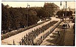
The German Eighth Army began its attack on 1 September, crossing the Dvina river south of the fortified Russian positions around the city. It was then split into two forces, with one attacking a nearby Russian corps that was threatening the bridgehead, while another advanced north along the river towards Riga. Most of the combat took place between with the former, near the Dvina bridgehead, when the Germans struck Russian positions further to the northeast along the Jugla river. Meanwhile, the second German force entered Riga with little resistance. But the fighting in the south and the march to Riga bought enough time for most of the Russian Twelfth Army to retreat from the city intact. The Germans captured only 9,000 Russian soldiers and overall the casualties were minimal on both sides. The fall of Riga weakened the Russian front line along the Baltic Sea, bringing German forces closer to Petrograd, and was followed by Operation Albion, a German amphibious landing on several islands in the Baltic. The offensive was also the first large scale use of stormtrooper infantry tactics by the German Army, which had been pioneered by Oskar von Hutier, before their use in the West during the 1918 spring offensive.

Lielā Jugla
Lielā Jugla

Lielā Jugla is a river of Latvia. It flows for 63 kilometres (the length would reach 118 km if the Mergupe river were counted as part of the Lielā Jugla), through the municipalities of Sigulda and Ropaži. The source of the river is located in Mālpils parish, Sigulda Municipality 71 m above sea level, whereas the mouth is 0.1 m asl. River slope is 1.1 m/km, annual drainage 0.26 km³. Lielā Jugla begins at the confluence of the Suda and Mergupe rivers in village Sidgunda.Lielā Jugla joins with Mazā Jugla thus forming the river Jugla shortly before its mouth into Jugla Lake at the Riga city eastern border with the municipality of Ropaži. The river is a water tourism site. The Ropaži hydroelectric plant is located on the river. Virtually the entire river flows along the Lowland of Central Latvia (Latvian: Viduslatvijas zemiene). The river meanders through a wooded area, the pool is heavily drained in some places. The shores are generally flat, with occasional Devonian bare rocks. There are many floodplains in the lower reaches of the mouths of rivers Krievupe and Tumšupe.From Sidgunda to Ropaži the river is 5-15 m wide. In and around Ropaži, the regime of the river is determined by the operation of the local hydroelectric power station (HES), where the river is crossed by a dam - a 1.5 m high concrete wall, which creates an artificial waterfall. A 1.5 km long left outflow begins at the dam, which forms an island with Ropaži Park and the municipality council on it. After the HES the river is calm and shallow in low water, before Bajāri begin thresholds and the river reaches a slope of 3.5 m/km. The thresholds end at Zaķumuiža, then the flow calms down again. At the mouth of Jugla Lake it meets the Mazā Jugla River, forming the Jugla River, the sediments of which as Jugla Delta penetrate deeply into the lake.In the river live pike, perch, roach, bream, eel.