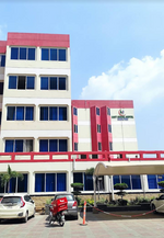
Military Hospital Rawalpindi
The Pak Emirates Military Hospital Rawalpindi is the largest hospital of the Pakistan Armed Forces, being one of the hospitals in the Pakistan Army with an ISO certification, located in the city of Rawalpindi. Before independence in 1947 it was called the British Indian Military Hospital Rawalpindi.Its commandant/CEO is a serving Major General of Army Medical Corps. It has one deputy commandant with the rank of brigadier and two assistant commandants (administrators) with the rank of Colonel. Its family wing is looked after by a Lady Medical Officer with the rank of brigadier. It is an affiliated hospital of the Army Medical College and Armed Forces Post Graduate Medical Institute, Rawalpindi. It is also a teaching institution for nurses and paramedics. The hospital, established in 1857, has 1200 beds for in-patient treatment. The hospital comprises three medical units, Departments of Surgery, Family Medicine, Dermatology, Pediatrics, Gynecology and Obstetrics, and Department of Intensive Care Units. The bed occupancy rate is about 95 percent.
Excerpt from the Wikipedia article Military Hospital Rawalpindi (License: CC BY-SA 3.0, Authors).Military Hospital Rawalpindi
Abid Majeed Road (Assaye Road),
Geographical coordinates (GPS) Address Nearby Places Show on map
 Continue reading on Wikipedia
 Geographical coordinates (GPS)
| Latitude | Longitude |
|---|---|
| N 33.594 ° | E 73.0436 ° |
Address
Military Hospital
Abid Majeed Road (Assaye Road)
23451 , Kamran Chowk
Punjab, Pakistan
Open on Google Maps