place

Altenburger Land

Altenburger LandDistricts of Thuringia

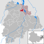
Altenburger Land is a district in Thuringia, Germany. It is bounded by (from the west and clockwise) the district of Greiz, the Burgenlandkreis (Saxony-Anhalt), and the districts Leipzig, Mittelsachsen and Zwickau in Saxony. The district is a member of the Central German Metropolitan Region.

Excerpt from the Wikipedia article Altenburger Land (License: CC BY-SA 3.0, Authors).

Altenburger Land
Stauffenbergstraße,

Geographical coordinates (GPS) Address Nearby Places
placeShow on map

Wikipedia: Altenburger LandContinue reading on Wikipedia

Geographical coordinates (GPS)

Latitude Longitude
N 51 ° E 12.416666666667 °
placeShow on map

Address

Stauffenbergstraße

Stauffenbergstraße
04600 , Nord (Altenburg)
Thuringia, Germany
mapOpen on Google Maps

Share experience

Nearby Places

Altenburg
Altenburg

Altenburg () is a city in Thuringia, Germany, located 40 kilometres (25 miles) south of Leipzig, 90 kilometres (56 miles) west of Dresden and 100 kilometres (62 miles) east of Erfurt. It is the capital of the Altenburger Land district and part of a polycentric old-industrial textile and metal production region between Gera, Zwickau and Chemnitz with more than 1 million inhabitants, while the city itself has a population of 33,000. Today, the city and its rural county is part of the Central German Metropolitan Region. Altenburg was first mentioned in 976 and later became one of the first German cities within former Slavic area, east of the Saale river (as part of the medieval Ostsiedlung movement). The emperor Frederick Barbarossa visited Altenburg several times between 1165 and 1188, hence the town is named a Barbarossa town today. Since the 17th century, Altenburg was the residence of different Ernestine duchies, of whom the Saxe-Altenburg persisted until the end of monarchy in Germany in 1918. Industrialization reached Altenburg and the region quite early in the first half of the 19th century and flourished until the Great Depression around 1930. Economic malaise set in while Altenburg was in East Germany and continued after German reunification in 1990, evidenced by a decline in population, high unemployment and house vacancy rates. The main sights of Altenburg are the castle, the Lindenau-Museum, the historic city center (most buildings are from early-modern origin) and the Gründerzeit architecture around the center. The popular German card game Skat was developed in Altenburg during the 1810s and the founder of the famous Brockhaus Enzyklopädie, Friedrich Arnold Brockhaus, lived and worked in Altenburg between 1810 and 1817. Altenburg lies in the flat and fertile landscape of Osterland on the Pleiße river in the very east of Thuringia, next to the neighboring federal state of Saxony.

Gerstenberg
Gerstenberg

Gerstenberg is a municipality in the district of Altenburger Land, in Thuringia, Germany. Gerstenberg was first mentioned in a document in 1227. The line of knights "von Gerstenberg" died out in 1710. As early as 1181, a fortification was mentioned in the district of Pöschwitz. This later manor passed into civil ownership in 1798. Members of the families served the dukes of Saxe-Gotha and Saxe-Altenburg. After the expropriation in 1951, what was once the largest farm was just a residential property with MTS and a small new farmer. Gerstenberg belonged to the Wettin office of Altenburg, [2] [3] which was under the sovereignty of the following Ernestine duchies from the 16th century due to several divisions in the course of its existence: Duchy of Saxony (1554 to 1572), Duchy of Saxony-Weimar (1572 to 1603 ), Duchy of Saxony-Altenburg (1603 to 1672), Duchy of Saxony-Gotha-Altenburg (1672 to 1826). When the Ernestine duchies were reorganized in 1826, the place again became part of the Duchy of Saxony-Altenburg. After the administrative reform in the duchy, it belonged to the Eastern District (until 1900) [4] and to the Altenburg district office (from 1900). [5] From 1918 the village belonged to the Free State of Saxony-Altenburg, which was added to the State of Thuringia in 1920. In 1922 it came to the district of Altenburg. The infrastructural modernization of the community began in 1880 with the establishment of the local volunteer fire brigade and continued in 1915 with the start of electrification and in 1952 with the construction of the first water pipeline. At the end of the Second World War in 1945, the place was initially occupied by the Americans and handed over to the Red Army in July 1945. On July 1, 1950, Pöschwitz was incorporated. During the second district reform in the GDR in 1952, the existing states were dissolved and the districts were redesigned. Thus, Gerstenberg came with the Altenburg district to the Leipzig district. In 1990 the place and the district of Altenburg became Thuringian again. Since 1994 it has belonged to the Altenburger Land district.