place

Mountain Rest

Buildings and structures in Hampshire County, MassachusettsHouses on the National Register of Historic Places in MassachusettsNational Register of Historic Places in Hampshire County, MassachusettsResidential buildings completed in 1902
GoshenMA MountainRestAveryCottage

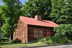
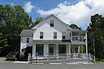
Mountain Rest is a historic religious summer retreat on Wildwood Lane, off Spruce Corner Road in Goshen, Massachusetts. Built in the first decade of the 20th century, it served as a retreat for Christian missionaries to foreign countries during periods of furlough in the United States, and as a training facility for future missionaries. The camp was listed on the National Register of Historic Places in 1983. The camp closed in 1970, and in 1987 the complex was converted to condominiums.

Excerpt from the Wikipedia article Mountain Rest (License: CC BY-SA 3.0, Authors, Images).

Mountain Rest
Wildwood Lane,

Geographical coordinates (GPS) Address Nearby Places
placeShow on map

Wikipedia: Mountain RestContinue reading on Wikipedia

Geographical coordinates (GPS)

Latitude Longitude
N 42.46 ° E -72.839722222222 °
placeShow on map

Address

Wildwood Lane 2
01032
Massachusetts, United States
mapOpen on Google Maps

GoshenMA MountainRestAveryCottage
Share experience

Nearby Places

Chesterfield Gorge (Massachusetts)

Chesterfield Gorge is a nature reserve located in Chesterfield, Massachusetts, United States. The property is owned by The Trustees of Reservations, who have administered the property since 1929. Chesterfield Gorge was initially carved from the metamorphic bedrock by torrents of glacial meltwater. Today, the gorge continues to be shaped by the East Branch of the Westfield River. The walls of the gorge are quite steep, more than 30 feet (9.1 m) in some places. During periods of low water, it is possible to get down to the floor of the gorge, but it is not recommended, and no trails exist from the cliff edge to the bottom. Rock climbing is prohibited. The surrounding forest features oak, pine, and hemlock, and is home to bears, bobcats, and turkeys, among many others. A half-mile trail along the cliff top offers views of the gorge, the river, and the forest. A railing runs along the length of the cliff for safety. Along the cliff ledge are fields of boulders, some of which are quite massive. Stone abutments of a bridge that once spanned the river are all that remain of the old post road between Boston, Massachusetts and Albany, New York. A toll gate was established at its eastern end, but no trace of it exists today. During the American Revolution, British redcoats marched over this bridge to Boston following General Burgoyne's defeat at Saratoga, New York. In 1835, floodwaters swept away the bridge along with some nearby grist and sawmills. A short trail leads along the river upstream from the gorge to the remains of the old bridge. A more extensive trail network extends southward down the river, through the Hiram H. Fox Wildlife Management Area and towards Knightville Dam. Chesterfield Gorge is the entrance to an extensive natural area along the Westfield River, and is designated a National Wild and Scenic River. Fly fishing for trout is a popular pastime. Atlantic salmon are stocked here, and must not be confused with the local trout, as it is illegal to keep them if caught. There is, coincidentally, a similar natural area named Chesterfield Gorge located in Chesterfield, New Hampshire.

Gate Cemetery
Gate Cemetery

Gate Cemetery is a historic cemetery on Ireland Street in West Chesterfield, Massachusetts. It is located just under one mile (1.6 km) south of the center of West Chesterfield, the junction of Main Road and Ireland Street. The 1/3 acre cemetery is on a plateau of land on the east side of Ireland Street, flanked to the east by the Westfield River and to the west by a steep hillside. It takes its name from a toll gate that was erected nearby when the area was settled in the late 18th century.The date of the cemetery's establishment is uncertain, but may be related to a deed transfer of land in the area to the town in 1794. The oldest grave marker, that of Joseph Gere, dates to 1808, while the latest (one of only three dated after 1959) is dated 1997. There are 121 full markers and 26 fragments, and there may be unmarked gravesites. The markers are laid out in 13 rows in the roughly rectangular plot. Most of the markers are marble, although there are number that are granite or slate. Five of the markers are obelisks; none of them exhibit any particular artistic sophistication. The plot is demarcated by fieldstone walls about four feet high; the entrance is marked by two granite posts, into which pockets are carved that hold wooden rails that must be removed to gain access to the grounds. None of the gravesites is fenced off, and there are no circulating paths or roadways on the grounds.The cemetery, along with the nearby Ireland Street Cemetery, was listed on the National Register of Historic Places in 2009.