place

Duchy of Cleves

1090s establishments in the Holy Roman Empire1092 establishments in Europe1795 disestablishments in the Holy Roman EmpireDuchies of the Holy Roman EmpireDuchy of Cleves
Early Modern NetherlandsEarly Modern history of GermanyFormer states and territories of North Rhine-WestphaliaHistory of GelderlandHistory of the RhinelandKleveLower Rhenish-Westphalian CircleMedieval GermanyMedieval NetherlandsStates and territories disestablished in 1795States and territories established in 1092
Die greue van Cleue ende vander Marck

The Duchy of Cleves (German: Herzogtum Kleve; Dutch: Hertogdom Kleef) was a State of the Holy Roman Empire which emerged from the medieval Hettergau. It was situated in the northern Rhineland on both sides of the Lower Rhine, around its capital Cleves and the towns of Wesel, Kalkar, Xanten, Emmerich, Rees and Duisburg bordering the lands of the Prince-Bishopric of Münster in the east and the Duchy of Brabant in the west. Its history is closely related to that of its southern neighbours: the Duchies of Jülich and Berg, as well as Guelders and the Westphalian county of Mark. The Duchy was archaically known as Cleveland in English. The duchy's territory roughly covered the present-day German districts of Cleves (northern part), Wesel and the city of Duisburg, as well as adjacent parts of the Limburg, North Brabant and Gelderland provinces in the Netherlands.

Excerpt from the Wikipedia article Duchy of Cleves (License: CC BY-SA 3.0, Authors, Images).

Duchy of Cleves
Kolpingstraße, Cleves Unterstadt

Geographical coordinates (GPS) Address Phone number Website Nearby Places
placeShow on map

Wikipedia: Duchy of ClevesContinue reading on Wikipedia

Geographical coordinates (GPS)

Latitude Longitude
N 51.783333333333 ° E 6.1333333333333 °
placeShow on map

Address

Evangelische Stiftung Kleve

Kolpingstraße
47533 Cleves, Unterstadt
North Rhine-Westphalia, Germany
mapOpen on Google Maps

Phone number

call+49282189660

Website
ev-stiftung.de

linkVisit website

Die greue van Cleue ende vander Marck
Share experience

Nearby Places

Bedburg-Hau
Bedburg-Hau

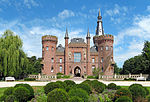
Bedburg-Hau is a municipality in the district of Kleve in the state of North Rhine-Westphalia, Germany. It is located approximately 5 km south-east of Kleve. One of its main attractions is Museum Schloss Moyland, a castle with a museum of modern art dedicated to the German artist Joseph Beuys. The park around the castle has a sculpture garden, herbal gardens and a rose garden. Castle Moyland was first documented in 1307. In the 1740s Frederick of Prussia used the castle to meet with a lover of his. In 1766 it came into possession of the von Steengracht family, and it remained in their possession until 1990 when the foundation Stiftung Museum Schloss Moyland was formed to care for it. Once a medieval moated castle, the Castle was converted to its current appearance in the 19th century by Cologne Cathedral architect Ernst Friedrich Zwirner, who transformed it in the Gothic Revival style. After being heavily damaged in World War II, it was only after the foundation was established that a comprehensive restoration was initiated, allowing the castle to serve its current purpose. The museum was opened in 1995. The reconstruction of Moyland Schloss was finally completed in 2007 with a topping ceremony when a replica of the historical spire was placed on top of the northtower. Bedburg-Hau is also home to St. Markus Church, which was built in 1124, and the mausoleum where Prince John Maurice von Nassau-Siegen was initially buried before his bodily remnants were brought to Siegen. A large area near the railway station is dedicated territory of the mental hospital LVR-Klinik Bedburg-Hau. The terrain was established around 1910, and now has many architectural monuments. Villages within the municipality of Bedburg-Hau are Hau, Hasselt, Huisberden, Louisendorf, Schneppenbaum, Till-Moyland and Qualburg.