Surrey—White Rock—North Delta
British Columbia geography stubsCanElecResTopTest with bare yearFormer federal electoral districts of British Columbia
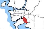
Surrey—White Rock—North Delta was a federal electoral district in British Columbia, Canada, that was represented in the House of Commons of Canada from 1979 to 1988. This riding was created in 1976 from parts of Burnaby—Richmond—Delta and Surrey—White Rock ridings. It was abolished in 1987 when it was redistributed into Delta, Surrey North and Surrey—White Rock ridings.
Excerpt from the Wikipedia article Surrey—White Rock—North Delta (License: CC BY-SA 3.0, Authors).Surrey—White Rock—North Delta
Lambert Crescent, Delta Sunshine Hills (North Delta)
Geographical coordinates (GPS) Address Nearby Places Show on map
Geographical coordinates (GPS)
| Latitude | Longitude |
|---|---|
| N 49.122 ° | E -122.905 ° |
Address
Lambert Crescent 6569
V4E 1V4 Delta, Sunshine Hills (North Delta)
British Columbia, Canada
Open on Google Maps


