place

Egypt, Pennsylvania

1733 establishments in Pennsylvania1733 establishments in the Thirteen ColoniesCensus-designated places in Lehigh County, PennsylvaniaPages with non-numeric formatnum argumentsPopulated places established in 1733
Unincorporated communities in Lehigh County, PennsylvaniaUnincorporated communities in PennsylvaniaUse mdy dates from July 2023
Egypt Community Church, Egypt, PA looking east

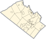
Egypt (Pennsylvania German: Iegypden) is an unincorporated community and census-designated place (CDP) in Whitehall Township in Lehigh County, Pennsylvania, United States. The population of Egypt was 2,588 as of the 2020 census.Egypt is located about 7 miles (11 km) north of Allentown and is part of the Lehigh Valley metropolitan area, which had a population of 861,899 and was the 68th-most populous metropolitan area in the U.S. as of the 2020 census.

Excerpt from the Wikipedia article Egypt, Pennsylvania (License: CC BY-SA 3.0, Authors, Images).

Egypt, Pennsylvania
Church Street, Whitehall

Geographical coordinates (GPS) Address Nearby Places
placeShow on map

Wikipedia: Egypt, PennsylvaniaContinue reading on Wikipedia

Geographical coordinates (GPS)

Latitude Longitude
N 40.68 ° E -75.53 °
placeShow on map

Address

Church Street

Church Street
18037 Whitehall
Pennsylvania, United States
mapOpen on Google Maps

Egypt Community Church, Egypt, PA looking east
Share experience

Nearby Places

Fort Deshler
Fort Deshler

Fort Deshler, located near Egypt, Lehigh County, Pennsylvania, USA, was a French and Indian War era frontier fort established in 1760 to protect settlers from Indian attacks. The fort was near the location of what is now the intersection of Pennsylvania Route 145 and Chestnut Street, between Egypt and Coplay. The fort was built by Adam Deshler, who was employed during the French and Indian War furnishing provisions for provincial forces. It was actually a fortified stone blockhouse, 40 feet (12 m) long and 30 feet (9.1 m) wide, with walls 2.5 feet (0.76 m) thick, that was also as Deshler's home. Adjoining the building was a large wooden building, suitable as barracks for 20 soldiers and for storing military supplies.There appears to be no evidence that the fort was either garrisoned with provincial troops or served any military purpose beyond functioning as a place of refuge and rendezvous for settlers of the region.The fort remained in the Deshler family until 1899, when the building and its remaining 151 acres (0.61 km2; 0.24 sq mi) of property were sold to the Coplay Cement Company for $100,000.The historian Charles Rhoads Roberts, in his 1914 History of Lehigh County Pennsylvania and a Genealogical and Biographical Records of its Families, wrote the following about Fort Deshler: This old stone mansion, the only building standing in Lehigh County which was used as a fort in the colonial period, should by all means be preserved and marked as a historic spot, not only as a memorial to the pioneers of this location but also as a reminder to the coming generations of the hardships which their staunch and sturdy ancestors were compelled to undergo. Fort Deshler was not preserved, and stood in ruins until it collapsed around 1940. Its location is commemorated by a Pennsylvania Historical and Museum Commission marker.

Coplay Cement Company Kilns

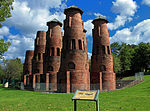
Coplay Cement Company Kilns, also known as the Saylor Park Industrial Museum, is an open-air historic site located at Coplay, Pennsylvania in Lehigh County, Pennsylvania. The nine kilns were built between 1892 and 1893 and used for the production of Portland cement. The kilns are constructed from locally produced red brick, and are known as Schoefer vertical kilns. They were shut down in 1904, and the Coplay Cement Company then donated them and the surrounding land to Lehigh County in 1975, which was used in creating a cement industry museum celebrating the important role the company and cement played in the area's early economic development. It is operated as a partnership between Lehigh County, which owns and maintains the site, and the Lehigh County Historical Society, which provides educational services. It was added to the National Register of Historic Places in 1980.The Saylor Cement Museum honors David Saylor (1827-1884), the father of the American Portland cement industry, and the people who built this industry into one of the most important in the Lehigh Valley and the nation. Lehigh County was a natural spot for cement production. Cement is made from rocks containing lime, silica, and alumina; Lehigh County limestone “cement rock” contains all three ingredients. In 1866, David O. Saylor helped found Coplay Cement Company. In 1871, he received the first American patent for Portland cement, which is much stronger than the natural cement that had previously been produced in this country. Saylor's Portland cement built bridges, docks, jetties, roads, aqueducts, subways, and skyscrapers. By 1900, the Lehigh Valley made 72% of Portland cement produced in this country.The first kiln at the Coplay Cement Company was a dome kiln. Dome kilns were inefficient; they had to shut down often. In 1893 Coplay Cement built Mill B, containing the Schoefer kilns standing today. Originally enclosed in a large building, Schoefer kilns could run continuously. Soon, however, the even more efficient rotary kilns came into use. Mill B's outdated Schoefer kilns shut down in 1904, and Coplay Cement later used Mill B's buildings for storage.

Lehigh Valley
Lehigh Valley

The Lehigh Valley (), known colloquially as The Valley, is a geographic and metropolitan region formed by the Lehigh River in Lehigh and Northampton Counties in eastern Pennsylvania. It is a component valley of the Great Appalachian Valley bounded to its north by Blue Mountain, to its south by South Mountain, to its west by Lebanon Valley, and to its east by the Delaware River and Warren County, New Jersey. The Valley is about 40 miles (64 km) long and 20 miles (32 km) wide. The Lehigh Valley's largest city is Allentown, the third-largest city in Pennsylvania and the county seat of Lehigh County, with a population of 125,845 residents as of the 2020 census.The Allentown–Bethlehem–Easton metropolitan area, which includes the Lehigh Valley, is currently Pennsylvania's third-most populous metropolitan area after those of Philadelphia and Pittsburgh, and the nation's 68th-largest metropolitan area with a population of 861,889 residents as of 2020. Lehigh County is among Pennsylvania's fastest-growing counties, and the Lehigh Valley leads Pennsylvania in terms of population growth in the 18- to 34-year old demographic, which constitutes a significant portion of the labor workforce. The region's core population centers are located in southern and central Lehigh and Northampton counties along Interstate 78, Interstate 476, Pennsylvania Route 309, and U.S. Route 22. The Lehigh Valley has historically been a global leader in steel and other heavy manufacturing industries, which represented a considerable portion of its employment and economic production for most of the 20th century. Beginning in the early 1980s, however, the region's heavy manufacturing sector experienced a rapid downfall, highlighted by the downsizing and ultimate closure of Bethlehem Steel, once the world's second-largest steel manufacturer, and other Valley-based manufacturing companies. The Valley's economy struggled considerably before ultimately rebounding and since emerging in the 21st century as one of Pennsylvania's largest and fastest-growing economies. As of 2021, the Lehigh Valley's gross domestic product (GDP) is $50.960 billion, driven by diverse industry sector contributions from its finance, manufacturing, health care and education, and information sectors. In the 21st century, the region also has emerged as a national center for the U.S. logistics industry, especially in warehousing and intermodal transport.The region's primary commercial airport is Lehigh Valley International Airport in Hanover Township; the airport's air traffic has grown considerably in the 21st century, largely as a result of considerable growth in its commercial air cargo traffic, which exceeded 210 million pounds in 2016.The Lehigh Valley is located within the U.S. Northeast megalopolis with ease of access and close proximity to many of the nation's largest population centers, airports, terminals, railways, and seaports, including New York City, the nation's largest city, which is 90 miles (140 km) to its east, and Philadelphia, the nation's sixth-most populous city, which is 60 miles (97 km) to its southeast. The region is located geographically within a one-day drive to over a third of the U.S. population and over half of Canada's population, which has been a factor in its 21st century emergence as a North American leader in light manufacturing and commercial distribution. Gains in these and other industries have helped offset the significant losses the region had experienced from its late 20th century decline in heavy manufacturing. Since its settlement in the 1700s, the Lehigh Valley has been the birthplace or home to several notable Americans who have proven influential across a broad range of fields, including academia, art and music, business, government and politics, the military, professional and Olympic-level athletics, and other fields.