place

Darfield railway station
Beeching closures in EnglandDisused railway stations in BarnsleyFormer Midland Railway stationsPages with no open date in Infobox stationRailway stations in Great Britain closed in 1963
Railway stations in Great Britain opened in 1840Use British English from March 2015Yorkshire and the Humber railway station stubs
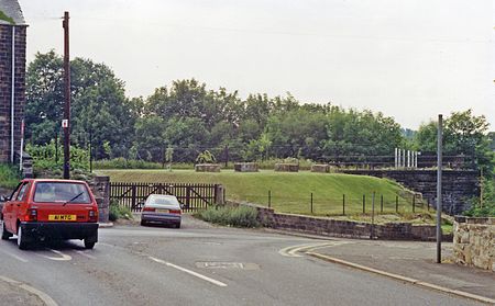
Darfield station site geograph 3402608 by Ben Brooksbank

Darfield railway station was opened in 1840 by the North Midland Railway, serving the village of Darfield in South Yorkshire, England. The original station building was of typical Francis Thompson Italianate design. Immediately north of it was Cat Hill Tunnel which was opened out when the line was quadrupled, and, in 1901, the station was rebuilt 15 chains further north next to the Doncaster road. A terrace of four cottages is shown on Ordnance Survey maps as "Railway Cottages" long after all other traces of the old station and its small goods yard had been removed. The last appearance of the cottages was on the OS map of 1955–56. Access to the cottages was by a drive which ran south to Cat Hill Road between Broomhill and the skew bridge which carried the railway over the road. The new station had typical Midland Railway timber panelled buildings. The new goods lines passed to the east. These had access to three major collieries - Grimethorpe, Dearne Valley and Houghton Main - and connected to the GCR and L&Y lines.The station closed in June 1963 and the line closed in 1988.

Excerpt from the Wikipedia article Darfield railway station (License: CC BY-SA 3.0, Authors, Images).

Darfield railway station
Cliff Drive,

Geographical coordinates (GPS) Address External links Nearby Places
placeShow on map

Wikipedia: Darfield railway stationContinue reading on Wikipedia

Geographical coordinates (GPS)

Latitude Longitude
N 53.53499 ° E -1.36296 °
placeShow on map

Address

Darfield

Cliff Drive
S73 9HU
England, United Kingdom
mapOpen on Google Maps

linkWikiData (Q5222578)
linkOpenStreetMap (4880938802)

Darfield station site geograph 3402608 by Ben Brooksbank
Share experience

Nearby Places

RSPB Dearne Valley Old Moor

RSPB Dearne Valley Old Moor is an 89-hectare (220-acre) wetlands nature reserve in the Dearne Valley near Barnsley, South Yorkshire, run by the Royal Society for the Protection of Birds (RSPB). It lies on the junction of the A633 and A6195 roads and is bordered by the Trans Pennine Trail long-distance path. Following the end of coal mining locally, the Dearne Valley had become a derelict post-industrial area, and the removal of soil to cover an adjacent polluted site enabled the creation of the wetlands at Old Moor. Old Moor is managed to benefit bitterns, breeding waders such as lapwings, redshanks and avocets, and wintering golden plovers. A calling male little bittern was present in the summers of 2015 and 2016. Passerine birds include a small colony of tree sparrows and good numbers of willow tits, thriving here despite a steep decline elsewhere in the UK. Barnsley Metropolitan Borough Council created the reserve, which opened in 1998, but the RSPB took over management of the site in 2003 and developed it further, with funding from several sources including the National Lottery Heritage Fund. The reserve, along with others nearby, forms part of a landscape-scale project to create wildlife habitat in the Dearne Valley. It is an 'Urban Gateway' site with facilities intended to attract visitors, particularly families. In 2018, the reserve had about 100,000 visits. The reserve may benefit in the future from new habitat creation beyond the reserve and improved accessibility, although there is also a potential threat to the reserve from climate change and flooding.