place

Somersham railway station

Beeching closures in EnglandDisused railway stations in CambridgeshireFormer Great Northern and Great Eastern Joint Railway stationsRailway stations in Great Britain closed in 1967Railway stations in Great Britain opened in 1848
Use British English from December 2016
Somersham station
Somersham station

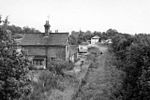
Somersham railway station was a station in Somersham, Cambridgeshire on the Great Eastern Railway between March and St Ives. There was also a branch line that ran north-west from the station to Ramsey. It opened in 1848, but was closed on 6 March 1967.The station was demolished and rebuilt at the private Fawley Railway Museum.

Excerpt from the Wikipedia article Somersham railway station (License: CC BY-SA 3.0, Authors, Images).

Somersham railway station
Ibbott Crescent, Huntingdonshire Somersham

Geographical coordinates (GPS) Address Nearby Places
placeShow on map

Wikipedia: Somersham railway stationContinue reading on Wikipedia

Geographical coordinates (GPS)

Latitude Longitude
N 52.3811 ° E 0.006 °
placeShow on map

Address

Somersham Local Nature Reserve

Ibbott Crescent
PE28 3JP Huntingdonshire, Somersham
England, United Kingdom
mapOpen on Google Maps

Somersham station
Somersham station
Share experience

Nearby Places

Old Bedford River
Old Bedford River

The Old Bedford River is an artificial, partial diversion of the waters of the River Great Ouse in the Fens of Cambridgeshire, England. It was named after the fourth Earl of Bedford who contracted with the local Commission of Sewers to drain the Great Level of the Fens beginning in 1630. It provided a steeper and shorter path for the waters of the Great Ouse, and was embanked to prevent them flooding the low ground of the South Fens. Throughout the project, the Earl and his Adventurers faced disruption from those who were opposed to drainage schemes. The project was deemed to have succeeded in draining the fens in 1637, but that decision was reversed in 1638. After a lull during the English Civil War, when much of the work was damaged, the Dutch engineer Cornelius Vermuyden worked with William Russell, the fifth Earl of Bedford to complete the drainage. Disruption and unrest continued while the work was carried out, resulting in the Adventurers employing armed guards. A second river, the New Bedford River, was cut parallel to the first channel, which then became the Old Bedford River. At some point, the Old Bedford River was split into two parts, when the upper section was diverted into the River Delph at Welches Dam, and the lower section was joined to the Counter Drain. Both parts retain the name, but are not connected to each other. The area between the two Bedford rivers acts as a large washland, which holds floodwater when the river channels cannot cope with the volume of water in them. The river acts as the outlet for a number of land drainage projects. Three internal drainage boards are located along its banks, and there are several pumping stations which pump water from low-lying fens into the Counter Drain and the lower section of the Old Bedford River. At the junction with the Great Ouse is Old Bedford Sluice, through which the water passes to reach the tidal river, but this is not always possible, particularly when high volumes of water are passing down the New Bedford River as a result of heavy rainfall further up the Great Ouse. To resolve this, a pumping station was built at Welches Dam in 1948, to pump water from the Counter Drain and lower Old Bedford River into the River Delph, which runs parallel to the lower river for most of it length, but then crosses the washland to enter the New Bedford River at Welmore Lake Sluice. When pumping occurs, flow in the lower river above Welney is reversed, and a vertical sluice gate prevents water discharged into the river by the Upwell Internal Drainage Board from reaching the pumping station. The river is navigable from Welches Dam to Old Bedford Sluice, but passage through the sluice can only be made when tidal water levels allow, as there is no lock. Welches Dam Lock used to provide a link from the Middle Level Navigations to the Great Ouse, which was the only link between the two river systems when Well Creek became unnavigable. However, a campaign to save Well Creek from being filled in was successful, and the recommended transfer route follows the old course of the River Nene and Well Creek to Salters Lode Lock at Denver. In 2006, the Environment Agency closed Welches Dam Lock, and despite campaigns for it to be reinstated, it has remained closed. There are proposals as part of the Fens Waterways Link which could result in more of the Old Bedford River becoming navigable, in order to provide a circular cruising route including parts of the Great Ouse and the Middle Level Navigations.

Cambridgeshire
Cambridgeshire

Cambridgeshire (abbreviated Cambs.) is a ceremonial county in the East of England and East Anglia. It is bordered by Lincolnshire to the north, Norfolk to the north-east, Suffolk to the east, Essex and Hertfordshire to the south, and Bedfordshire and Northamptonshire to the west. The largest settlement is the city of Peterborough, and the city of Cambridge is the county town. The county has an area of 3,389 km2 (1,309 sq mi) and a population of 852,523. Peterborough (179,349) and Cambridge (145,674), located in the north-west and south respectively, are by far the largest settlements. The remainder of the county is rural, and contains the city of Ely (20,112) and towns such as Wisbech and St Neots. Cambridgeshire contains six local government districts; five are part of a two-tier non-metropolitan county also called Cambridgeshire, and the district of Peterborough is a unitary area. The local authorities collaborate through Cambridgeshire and Peterbrough Combined Authority. The county did not historically include Huntingdonshire or the Soke of Peterborough, which was part of Northamptonshire. The north and east of the county are dominated by the Fens, an extremely flat, drained marsh maintained by drainage ditches and dykes. Holme Fen is the UK's lowest physical point, at 2.75 m (9 ft) below sea level. The flatness of the landscape makes the few areas of higher ground, such as that Ely is built on, very conspicuous. The landscape in the south and west is gently undulating. Cambridgeshire's principal rivers are the Nene, which flows through the north of the county and is canalised east of Peterborough; the Great Ouse, which flows from west to east past Huntingdon and Ely; and the Cam, a tributary of the Great Ouse which flows through Cambridge.

List of Sites of Special Scientific Interest in Cambridgeshire

Cambridgeshire is a county in eastern England, with an area of 339,746 hectares (1,312 sq mi) and a population as of mid-2015 of 841,218. It is crossed by the Nene and the Great Ouse rivers. The University of Cambridge, which was founded in the thirteenth century, made the county one of the country's most important intellectual centres. A large part of the county is in The Fens, and drainage of this habitat, which probably commenced in the Roman period and was largely completed by the seventeenth century, considerably increased the area available for agriculture.The administrative county was formed in 1974, incorporating most of the historic county of Huntingdonshire. Local government is divided between Cambridgeshire County Council and Peterborough City Council, which is a separate unitary authority. Under the county council, there are five district councils, Cambridge City Council, South Cambridgeshire District Council, East Cambridgeshire District Council, Huntingdonshire District Council and Fenland District Council.In England, Sites of Special Scientific Interest (SSSIs) are designated by Natural England, which is responsible for protecting England's natural environment. Designation as an SSSI gives legal protection to the most important wildlife and geological sites. As of March 2017, there are 99 sites designated in the county. There are eighty-eight sites listed for their biological interest, ten for their geological interest, and one for both interests. The largest site is Ouse Washes at 2,513.6 hectares (6,211 acres), which is partly in Norfolk. It is internationally important for its wintering and breeding waterfowl and waders, such as teal, pintail and wigeon. The smallest is Delph Bridge Drain at 0.1 hectares (0.25 acres), a short stretch of ditch which was designated because it was found to have a population of fen ragwort, which was believed to have been extinct in Britain since 1857. The only site designated for both biological and geological interests is Ely Pits and Meadows, which has nationally important numbers of bitterns, and has yielded sauropod dinosaurs and pliosaur marine reptiles dating to the Jurassic period.

List of local nature reserves in Cambridgeshire

Cambridgeshire is a county in eastern England, with an area of 1,308 square miles (3,390 km2) and a population as of 2011 of 708,719. It is crossed by two major rivers, the Nene and the Great Ouse. The main manufacturing area is Peterborough, and the foundation of the University of Cambridge in the thirteenth century made the county one of the country's most important intellectual centres. A large part of the county is in The Fens, and drainage of this habitat, which was probably commenced in the Roman period and largely completed by the seventeenth century, considerably increased the area available for agriculture.The administrative county was formed in 1974, incorporating most of the historic county of Huntingdonshire. Local government is divided between Cambridgeshire County Council and Peterborough City Council, which is a separate unitary authority. Under the county council, there are five district councils, Cambridge City Council, South Cambridgeshire District Council, East Cambridgeshire District Council, Huntingdonshire District Council and Fenland District Council.Local nature reserves (LNRs) are designated by local authorities, which must have legal control over the site, by owning it, leasing it or having an agreement with the owner. LNRs are sites which have a special local interest biologically, geologically or for education. Local authorities can either manage sites themselves or through other groups such as "friends of" and wildlife trusts, and can apply local bye-laws to manage and protect LNRs.There are twenty-seven LNRs in Cambridgeshire. Four are Sites of Special Scientific Interest, and five are managed by the Wildlife Trust for Bedfordshire, Cambridgeshire and Northamptonshire. The largest is Little Paxton Pits at sixty hectares, which is of national importance for wintering wildfowl, and the smallest is St Denis Churchyard, East Hatley, which has grassland with diverse flowers. There is public access to all sites.