Meig's Key
Biscayne National ParkIslands of FloridaIslands of the Florida KeysMonroe County, Florida geography stubsUninhabited islands of Miami-Dade County, Florida
.jpg)
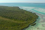
Meig's Key is a small island north of the upper Florida Keys in Biscayne National Park. It is in Miami-Dade County, Florida. It is located in southern Biscayne Bay, just north of Old Rhodes Key and Totten Key, just southeast off the southern tip of Elliott Key, and due south of Adams Key. It is on the south side of Caesar Creek, the creek that separates Elliott and Old Rhodes Keys.
Excerpt from the Wikipedia article Meig's Key (License: CC BY-SA 3.0, Authors, Images).Meig's Key
Adams Key Trail,
Geographical coordinates (GPS) Address Nearby Places Show on map
 Continue reading on Wikipedia
 Geographical coordinates (GPS)
| Latitude | Longitude |
|---|---|
| N 25.3934 ° | E -80.234 ° |
Address
Adams Key Trail
Adams Key Trail
Florida, United States
Open on Google Maps