Worthington Ridge Historic District
Berlin, ConnecticutColonial Revival architecture in ConnecticutGeorgian Revival architecture in ConnecticutHistoric districts in Hartford County, ConnecticutHistoric districts on the National Register of Historic Places in Connecticut ... and 3 more
NRHP infobox with nocatNational Register of Historic Places in Hartford County, ConnecticutVictorian architecture in Connecticut

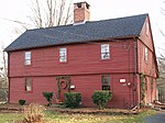
The Worthington Ridge Historic District encompasses the historic town center of Berlin, Connecticut. It runs mostly along Worthington Ridge Road from the intersection of Mill Street (Route 372) to Sunset Lane. This section of road was historically part of the Boston Post Road laid out in 1673, and is now lined by a diversity of residential architecture and several of the town's civic buildings. In 1974, the Berlin Historic District was formed in order to preserve the integrity of the architecture of the village. The district was listed on the National Register of Historic Places in 1989.
Excerpt from the Wikipedia article Worthington Ridge Historic District (License: CC BY-SA 3.0, Authors, Images).Worthington Ridge Historic District
Hudson Street,
Geographical coordinates (GPS) Address External links Nearby Places Show on map
Geographical coordinates (GPS)
| Latitude | Longitude |
|---|---|
| N 41.618333333333 ° | E -72.746944444444 ° |
Address
Worthington Ridge Historic District
Hudson Street
06037
Connecticut, United States
Open on Google Maps


