Fung Hang
Hong Kong geography stubsVillages in North District, Hong Kong

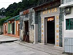
Fung Hang (Chinese: 鳳坑) is a village in the north eastern New Territories of Hong Kong, to the south west of the Sha Tau Kok Hoi or Starling Inlet, opposite the town of Sha Tau Kok. It is a single-clan Hakka village of the Cheung (張) Clan located between Luk Keng and Kuk Po.
Excerpt from the Wikipedia article Fung Hang (License: CC BY-SA 3.0, Authors, Images).Fung Hang
鳳坑家樂徑 Fung Hang Family Walk, North District
Geographical coordinates (GPS) Address Nearby Places Show on map
 Continue reading on Wikipedia
 Geographical coordinates (GPS)
| Latitude | Longitude |
|---|---|
| N 22.528076 ° | E 114.225667 ° |
Address
鳳坑公廁 Fung Hang Public Toilet
鳳坑家樂徑 Fung Hang Family Walk
518081 North District
Hong Kong, China
Open on Google Maps